NSW bioregions
Land bioregions
The 18 bioregions in NSW cover a wide diversity of landscapes. NSW has a total area of 80,160,000 hectares. Eighteen of the 89 Australian bioregions are represented in NSW, but only two of these 18 bioregions, Cobar Peneplain and NSW North Coast, lie wholly within the NSW boundary. The other 16 are shared with the bordering states and territories.
The diversity of NSW landscapes is evident in the wide range of the state's bioregions, see Tabled BR.1.
Western NSW
- Sandy deserts – Simpson-Strzelecki Dunefields, Channel Country, Murray–Darling Depression
- Riverine plains – Riverina, Darling Riverine Plains
- Rocky ranges – Mulga Lands, Broken Hill Complex
- Rolling downs – Cobar Peneplain.
Eastern NSW
- Lush rainforests – NSW North Coast, South East Corner, South East Queensland
- Rugged mountains – Sydney Basin, New England Tableland, Australian Alps, South Eastern Highlands
- Undulating ranges – Brigalow Belt South, Nandewar
- Fragile, wooded grasslands – NSW South Western Slopes.
Table BR.1: NSW bioregions and the proportion of each in NSW
| IBRA Region Name | IBRA Area in NSW (ha) | % Percentage of bioregion in NSW |
|---|---|---|
| Australian Alps (AUA) | 464,034 | 37.64 |
| Brigalow Belt South (BBS) | 5,623,054 | 20.66 |
| Broken Hill Complex (BHC) | 3,766,741 | 66.84 |
| Channel Country (CHC) | 2,335,604 | 7.68 |
| Cobar Peneplain (COP) | 7,385,346 | 100.00 |
| Darling Riverine Plains (DRP) | 9,413,084 | 87.97 |
| Mulga Lands (MUL) | 6,581,779 | 26.13 |
| Murray Darling Depression (MDD) | 7,949,169 | 39.83 |
| Nandewar (NAN) | 2,072,816 | 76.71 |
| New England Tablelands (NET) | 2,857,082 | 95.17 |
| NSW North Coast (NNC) | 3,996,591 | 100.00 |
| NSW South Western Slopes (NSS) | 8,114,379 | 93.47 |
| Riverina (RIV) | 7,030,950 | 72.45 |
| Simpson Strzelecki Dunefields (SSD) | 1,094,314 | 3.91 |
| South East Corner (SEC) | 1,206,479 | 47.65 |
| South Eastern Highlands (SEH) | 4,945,318 | 59.04 |
| South Eastern Queensland (SEQ) | 1,655,317 | 21.21 |
| Sydney Basin (SYB) | 3,622,939 | 99.82 |
| Total | 80,115,007 |
Notes:
Area is based on calculated GIS_AREA data. GIS_AREA is the area in hectares based on current spatial data and an Albers equal area projection for Australia.
Marine bioregions
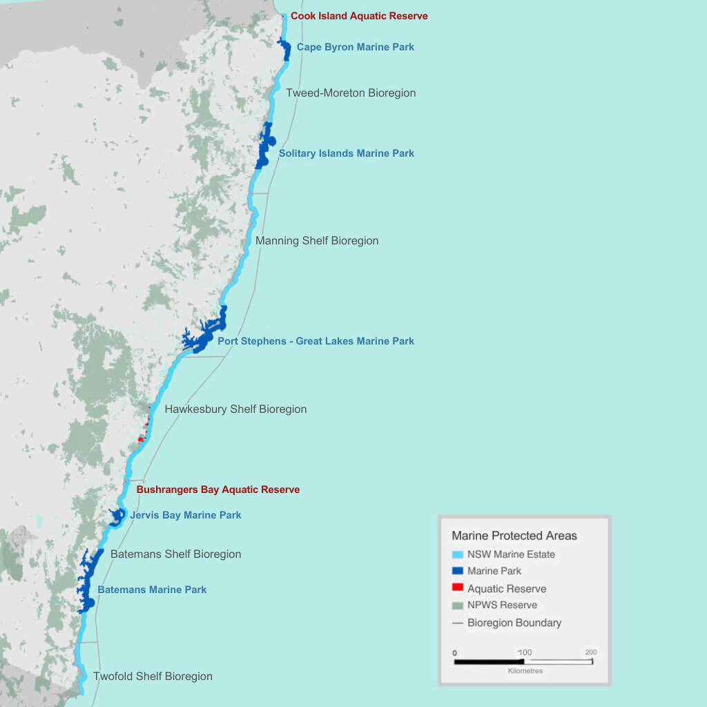
There are six bioregions in NSW – five off the coast and one surrounding Lord Howe Island, Aquatic reserves.
The 5 adjacent bioregions are defined by the Integrated Marine and Coastal Regionalisation of Australia (IMCRA), A Guide to the Integrated Marine and Coastal Regionalisation of Australia version 4.0. The guide is dated June 2006.
As seen in Map BR.1, the five bioregions are (north to south):
- Tweed-Moreton
- Manning Shelf
- Hawkesbury Shelf
- Batemans Shelf
- Twofold Shelf.
Map BR.1: Map of the five bioregions along NSW coastline
Notes:
Cropped and edited original map for web format.