Summary
Overall extractions from all NSW metered groundwater sources are mostly within the long-term average annual extraction limits. Knowledge of NSW groundwater-dependent ecosystems has improved, but their actual extent and condition remain uncertain.
Groundwater extraction decreased between 2014–15 and 2016–17, reflecting seasonal conditions that reduced demand on groundwater resources during this period.
Water sharing plans now ensure that groundwater is managed at the water-source scale to the long-term average annual extraction limit. Extraction from the major alluvial systems of the Lower Gwydir, Upper and Lower Namoi, Lower Macquarie, Lower Lachlan, Lower Murrumbidgee and Lower Murray Rivers fluctuates around levels close to the limits for sustainability. However, the overall level of groundwater extracted from all metered sources in NSW is much lower than the cumulative sustainable extraction limit.
Eleven water resource plans (WRPs) focusing on groundwater will be developed by 2019. These will set out arrangements to share water for consumptive use, establish rules to meet environmental and water quality objectives, and take into account potential and emerging risks to water.
Related topic Water Resources
NSW indicators
| Indicator and status | Environmental trend |
Information reliability |
|
|---|---|---|---|
| Long-term extraction limit: entitlement |
|
Getting better | ✔✔ |
| Aquifer integrity |
|
Stable | ✔ |
| Groundwater quality |
|
Stable | ✔ |
| Condition of groundwater-dependent ecosystems | Unknown | Unknown | ✔ |
Notes:
Terms and symbols used above are defined in How to use this report.
Context
Where surface water is available, groundwater is often seen as a supplementary water resource. However, in areas beyond the close proximity of rivers, both surface water and groundwater are primary water resources. Widely used in agriculture and industry, groundwater is also the primary water source in many NSW regional communities, for drinking and domestic and stock use.
Those who manage groundwater depend heavily on data from monitoring bores and groundwater extraction data. Managing groundwater is complex because each source is unique in composition and size. Many factors determine how each source functions. This means sources cannot all be managed the same way.
Locally, it is possible to limit groundwater extraction rates from individual bores. This is a way to manage impacts on third parties, such as other users, and on the aquifer system and groundwater-dependent ecosystems (GDEs). If not managed, third-party impacts can be significant.
The many ecosystems that depend on groundwater to survive include:
- highly-specialised and endemic subterranean systems
- surface water systems (wetlands, rivers and lakes) connected to groundwater
- some land-based ecosystems.
When the amount or quality of available groundwater changes significantly, this can degrade ecosystems and affect human uses of this water. Because many groundwater-dependent ecosystems are hidden underground, impacts to them are likely to be less obvious and less well understood.
Status and Trends
Extent and major uses of groundwater
Approximately 11% of all water used in NSW comes from groundwater sources. Together, domestic use (including drinking water) and watering stock consume around 13% of total estimated groundwater used in NSW. For more than 200 towns in NSW, groundwater is the principal water supply source.
Agriculture is by far the greatest user of groundwater in NSW. Most of this water is used to irrigate along inland floodplains underlain by high quality alluvial aquifers.
Although groundwater is also used by some mining operations, for others it is an obstruction or hazard to extract before mining can proceed.
Groundwater resources in NSW
Groundwater, found throughout NSW's landscape, ranges in depth and salinity, and this affects its availability to the environment or extractive users.
The upper groundwater bearing zone, or water table aquifer, is typically the most important groundwater system for GDEs, and for groundwater's connection with surface water. Climate, topography, and permeability of the host geology strongly influence this water resource. In higher rainfall areas in eastern NSW, groundwater tends to be shallower and salinity lower; depth and salinity increase going westward, where evaporation rates are higher and the topography flatter.
The different types of groundwater aquifers in NSW also differ in their yields:
- Unconsolidated sediments in alluvial floodplain and coastal sand beds yield the greatest groundwater supplies because they are more permeable.
- Consolidated porous rocks of the sedimentary basins have varying groundwater yields and salinity, from freshwater in the Great Artesian Basin to higher-salinity groundwater found with some coal deposits.
- Fractured rock groundwater systems typically have low groundwater yields — basalt aquifers on NSW's north coast are among the notable exceptions.
Levels of groundwater extraction and recharge
In large areas of NSW, the potential to extract groundwater is low due to unfavourable hydrogeology or unsuitable water quality. About 98% of all metered groundwater extracted in NSW comes from inland alluvial groundwater sources. These sources include high-yielding aquifers with good-quality water used extensively for irrigation.
Six major inland alluvial aquifers account for about 80% of all metered groundwater use:
- Lower Gwydir
- Upper and Lower Namoi
- Lower Macquarie
- Lower Lachlan
- Lower Murrumbidgee
- Lower Murray Rivers.
The Upper Lachlan and Mid Murrumbidgee sources make notable contributions to the remaining 20% of metered groundwater use.
Figure 19.1 shows groundwater extraction from all metered aquifers in NSW and the major inland alluvial aquifers, for the 16-year period to 30 June 2017. It reveals two extraction peaks, in 2002–03 and 2006–07, during periods of particularly acute droughts when surface water availability was low.
From 2006–07 to 2010–11, groundwater extraction gradually declined as water sharing plans were introduced and rainfall and surface water availability increased. Then, between 2011–12 and 2014–15, groundwater extraction from all NSW water sources, including major inland alluvial aquifers, gradually increased, from a 2010–11 low. This increase reflects greater demand for groundwater during a period when rainfall and surface water availability were low, particularly in valleys of northern NSW. In the three years to 2017, groundwater extraction again declined as rainfall and surface water availability improved.
The quantity of groundwater extracted from the six major inland alluvial aquifers fluctuates around levels close to the limits for sustainability. Nevertheless, the total quantity of groundwater extracted from all metered sources in NSW is well within the long-term average annual extraction limits.
Figure 19.1: Annual levels of groundwater extraction from metered aquifers in NSW and the major inland alluvial aquifers, 2001–02 to 2016–17
Notes:
The major inland alluvial aquifers are those of the Lower Gwydir, Lower and Upper Namoi, Lower Macquarie, Lower Lachlan, Lower Murrumbidgee and the Lower Murray rivers.
The orange line is the long-term average annual extraction limit (LTAAEL) for these major groundwater sources only. The LTAAEL is the level of water that can be extracted annually on a sustainable basis over a longer time frame.
The red line is the LTAAEL for all metered extraction in NSW.
Extraction limits were reduced gradually to align with the LTAAEL by the final year of relevant water sharing plans, 2016–17.
Long-term average annual extraction limits
Climate variations affect how much groundwater people use. Groundwater is managed on a long-term average basis, an approach that ensures groundwater systems, with their large storage capacities, provide a buffer to supply water in times of drought. During droughts, groundwater extraction may increase to offset decreases in surface water, and levels decline. In periods of high rainfall, demand for groundwater decreases; this allows levels to recover, sustaining a reliable and secure water resource.
For groundwater sources defined in water sharing plans, the long-term average annual extraction limit (LTAAEL) is the volume of groundwater that can be extracted on an annual average basis over the longer term. It is effectively the plan limit.
To manage compliance with the LTAAEL, each water sharing plan sets rules. These rules aim to prevent annual groundwater extractions, over a set rolling average period, from exceeding the LTAAEL by a set percentage. If extraction exceeds this, the plan allows for reductions in available water determinations (AWDs) for aquifer access licences (AAL). These reduced allocations to licensed groundwater users bring groundwater extraction back to the LTAAEL. In unregulated river systems, joint management rules may be established and used to guide reductions in AWDs.
Managers in some large inland alluvial systems use numeric groundwater models to inform the limits set for extraction. By simulating groundwater flow over years, these models provide insights into how groundwater systems respond to climate variations and pumping stresses. In other inland alluvial areas, previous levels of groundwater extraction are used to set the extraction limit; this limits any growth in groundwater pumping.
In many coastal alluvial systems, the limit simply corresponds to current levels of entitlement.
In the remaining groundwater systems, managers use the estimated rainfall recharge to inform the extraction limit they set. In these systems an extraction volume, equal to a portion of long-term average rainfall recharge, is permitted each year.
All water not explicitly permitted for extraction is reserved as environmental water. This reserve protects important environmental assets and ensures groundwater sources remain viable over the long term.
Water sharing plans and extraction levels
Water sharing plans allocate water for the environment, town water supplies, basic landholder rights and commercial uses (such as irrigation). These plans manage extraction to the LTAAEL.
By applying progressive allocation reductions over their 10-year plans, managers addressed historical groundwater use above their plans' extraction limit in the six major inland alluvial aquifers (Lower Gwydir, Upper and Lower Namoi, Lower Macquarie, Lower Lachlan, Lower Murrumbidgee and the Lower Murray). See Figure 19.2.
Figure 19.2: Allocations to groundwater under water sharing plans in the six major inland alluvial aquifers
In other over-committed groundwater systems, water use is being managed to water sharing plan extraction limits by annual allocations. In these systems, groundwater was not historically extracted above limits. The focus is therefore to limit future growth in groundwater extraction, rather than reduce access to water that users are economically reliant on.
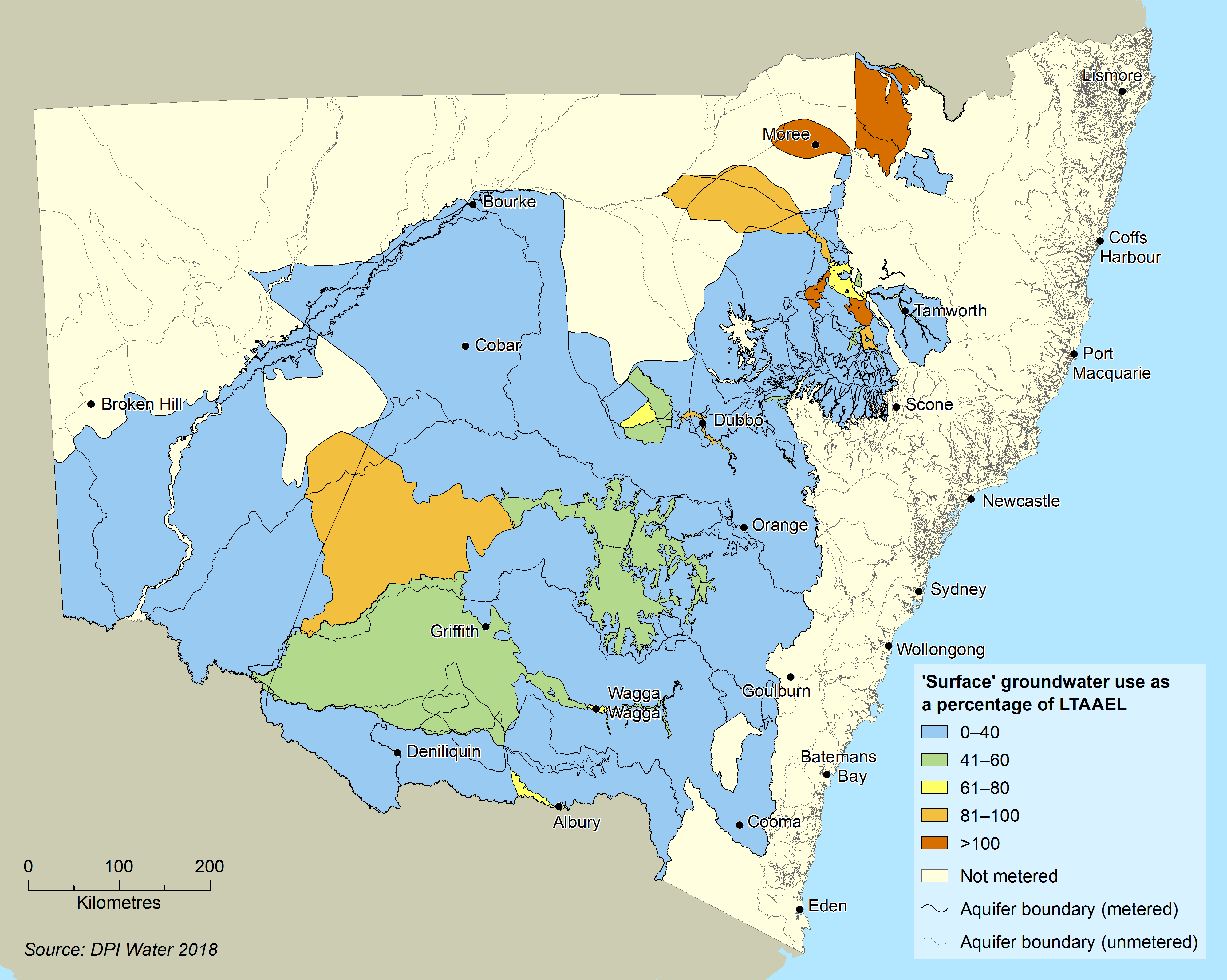
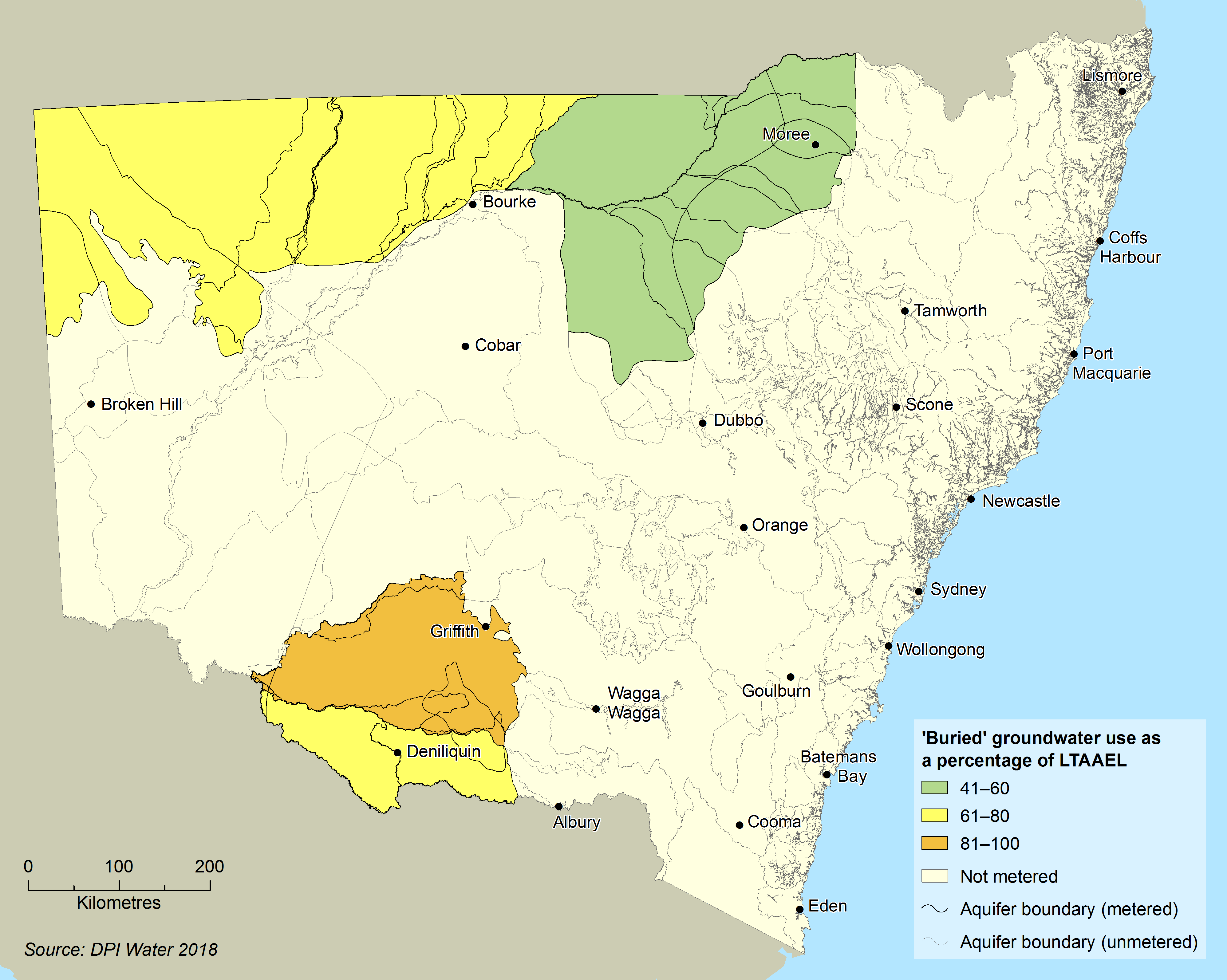
Maps 19.1 and 19.2 show average groundwater use as a percentage of long-term average annual extraction limits for the period 2015–2017 for surface and buried sources respectively, in areas where groundwater use is metered and monitored.
Map 19.1: Extraction from NSW surface aquifers as a percentage of the long-term average annual extraction limit
Notes:
Only areas where groundwater use is metered are shown on the map.
Map 19.2: Extraction from NSW buried aquifers as a percentage of the long-term average annual extraction limit
Notes:
Only areas where groundwater use is metered are shown on the map.
All water sharing plans have compliance rules to manage extraction to the LTAAEL over time. If extractions exceed the limit, the plan's compliance triggers, and groundwater allocations may be reduced until extraction is brought back to the LTAAEL.
Water resource plans
The Commonwealth Basin Plan 2012 requires NSW to develop 20 water resource plans by 2019, 11 of them for groundwater. The water resource plans' fundamental role is to ensure managers implement sustainable diversion limits (SDLs) set by the Basin Plan, from 2019 and beyond.
Water resource plans set out arrangements to:
- share water used for consumption
- establish rules to meet environmental and water quality objectives
- account for potential and emerging risks to water resources.
See the Water Resources topic.
Groundwater-dependent ecosystems
Water sharing plans describe groundwater-dependent ecosystems as, 'ecosystems where the species composition or natural functions depend on the availability of groundwater'. These ecosystems depend completely or partially on groundwater, such as during periods of drought when surface water is not available. The degree and nature of their dependency influences how much these ecosystems are affected by changes to groundwater quality or quantity.
Groundwater-dependent ecosystems are found in a wide range of environments, from highly-specialised subterranean ecosystems to more generally occurring land, freshwater and marine ecosystems (Eamus & Froend 2008). Seven broad types of GDEs, falling into two main groupings are defined according to their ecology, geomorphology and water chemistry.
Subsurface ecosystems:
- subsurface phreatic aquifer ecosystem
- karsts and caves
- subsurface baseflow streams.
Surface ecosystems:
- surface baseflow streams
- wetlands
- estuarine and near-shore marine ecosystems
- groundwater-dependent or phreatophytic vegetation.
Underground springs and cave systems host the most significant, diverse, and potentially sensitive groundwater-dependent ecosystems and organisms.
Identifying groundwater-dependent ecosystems
The NSW State Groundwater Dependent Ecosystem Policy (DLWC 2002) was introduced in 2002, and ongoing work by the NSW Government to identify GDEs across the state has improved knowledge. Current mapping, completed statewide, is available through the BOM GDE Atlas, which provides the latest dataset of GDEs.
Pressures
Excessive demand and extraction
Reducing an aquifer's storage levels, or consistently mining its water resource beyond the recharge rate, affect its long-term stability and integrity. This has permanent consequences for all dependent ecosystems and beneficial uses. Competition for groundwater resources can place the long-term security of these resources at risk.
Saline intrusion and groundwater quality
Intrusion of salty water into aquifers has detrimental effects on water quality and related uses. Saline intrusion of depleted aquifers is a high risk where:
- groundwater extraction is high
- the aquifer is overlain or underlain by saline aquifers
- the aquifer is near the coast.
Coastal sand beds north of Newcastle exemplify the risk of saline intrusion in this important water source for Greater Newcastle. To manage this risk, bore monitoring sites in the Tomago and Tomaree water sources were constructed along several transects, to monitor for changes in seawater intrusion. Each bore has specific triggers linked to response procedures under Hunter Water Corporation’s Sustainable Groundwater Extractions Strategy.
Further north, in the Stuarts Point Water Source, the NSW Government constructed a series of bores aligned in transects to monitor for seawater intrusion. Each bore uses automatic data loggers to collect hourly salinity data.
Studies of risks to groundwater quality from high-volume groundwater extraction in the six major inland alluvial aquifers reveal localised areas of water quality decline. Strategies are being developed to address these risks.
Chemical contamination
Chemical contamination of groundwater reduces its value for users and the environment and increases water treatment costs. Such contamination can even prevent some types of water use altogether. Once polluted, an aquifer is extremely difficult and expensive to restore.
Groundwater contamination is largely associated with areas of long-standing industrial activity (existing or former). Such areas are found around Sydney, Newcastle and Wollongong.
Responses
Legislation and policies
Water Management Act 2000
Under the Water Management Act 2000, all groundwater aquifers must be managed sustainably. Statutory water sharing plans for groundwater are used to implement this sustainable management.
NSW State Groundwater Dependent Ecosystems Policy
The NSW State Groundwater Dependent Ecosystems Policy (DLWC 2002) has guidelines on how to protect and manage GDEs. Ongoing work seeks to improve understanding of the location of these ecosystems and determine the extent of their reliance on groundwater.
NSW Aquifer Interference Policy
The NSW Aquifer Interference Policy (DPI 2012) is part of the NSW Government’s Strategic Regional Land Use Policy. The policy details how to assess and license potential impacts to aquifers, such as mining and coal seam gas (CSG) extraction activities. It aims to balance water requirements of towns, farmers, industry and the environment. This policy plays an important role in assessments for proposed mining and CSG developments. Because the Aquifer Interference Approval provisions of the Water Management Act 2000 have not been enacted, some groundwater-related activities are still administered under the Water Act 1912.
Programs
Cap and Pipe the Bores Program
Since the 1990s, various programs have sought to reduce water wastage and improve groundwater pressure by capping and piping bores across the Great Artesian Basin located beneath parts of NSW, Queensland, the Northern Territory and South Australia.
The Cap and Pipe the Bores Program gives landowners financial incentives to offset the costs of replacing uncapped artesian bores and open drains with rehabilitated bores and efficient pipeline systems. These pipeline systems provide water to properties, prevent large quantities of salt from entering drainage systems, and help drought-proof properties. The program's measures have produced water savings of 78,500ML annually in the NSW part of the Great Artesian Basin, and water pressure across the basin has increased. A further joint Commonwealth–NSW Government phase of the program was announced in early 2018.
Future opportunities
Metering
Many groundwater management areas do not yet report meter readings. In these areas, information on groundwater recharge and availability is currently estimated using limited data and conceptual models.
Under a draft NSW metering framework announced in June 2018, the NSW Government proposes to meter approximately 95% of existing licensed water take capacity. Under the framework, groundwater extraction works of 200mm or larger must be metered. The framework proposes a requirement that telemetry be attached to meters. These proposed measures would make water take data capture and reporting more timely and efficient.
Non-metered take of groundwater also presents opportunities for better measuring, modelling, and hydrometrics. As part of agreed actions under the Murray-Darling Basin Compliance Compact, the NSW Government has committed to manage basin water resources using best available data and emerging technology. Better monitoring of water extracted will improve groundwater recharge models and help managers set extraction limits with greater accuracy.
The connections between groundwater and surface water systems is an area where knowledge and understanding could be improved. If closely-linked, such water systems have the potential to be managed holistically as a single integrated resource — another area in which groundwater management could benefit from further development.
Allocation
Some groundwater sources are not yet allocated. A process for controlled allocation of a proportion of this water has been formulated; such allocations are only made if they do not adversely affect surface water flows, other groundwater users, or the environment. Three controlled allocations of these groundwater sources have already been made, and new allocation orders are planned for release in 2019.
Groundwater-dependent ecosystems
Knowledge of groundwater-dependent ecosystems is still emerging. Better understanding of their location, characteristics, and levels of dependency on groundwater is needed. Little is also known about plants and animals living within, or dependent on, groundwater aquifers. These knowledge gaps make it difficult to manage groundwater systems in ways that will protect them.
However, two key stages of work to better identify the state's GDEs are now complete. First, the Department of Industry - Water released comprehensive mapping of high-probability GDEs. Read the report.
Second, GDEs were prioritised so they could be better managed, by assigning an ecological value to high probability GDEs. Methods used to assign them are based on the High Ecological Value Aquatic Ecosystem (HEVAE) framework (Aquatic Ecosystems Task Group 2012). This work identified a subset of high-probability, high-value GDEs across NSW. Going forward, managers can consider the risks to these GDEs posed by water extraction. They can determine whether controls are required to manage these risks, and whether monitoring or more information is needed.
References
References for Groundwater
Aquatic Ecosystems Task Group 2012, Aquatic Ecosystems Toolkit. Module 3: Guidelines for Identifying High Ecological Value Aquatic Ecosystems (HEVAE), Australian Government Department of Sustainability, Environment, Water, Population and Communities, Canberra [http://www.environment.gov.au/topics/water/commonwealth-environmental-water-office/monitoring-and-evaluation/aquatic-ecosystems]
DLWC 2002, The NSW State Groundwater Dependent Ecosystems Policy, Department of Land and Water Conservation, Sydney [http://www.water.nsw.gov.au/__data/assets/pdf_file/0005/547844/groundwater_dependent_ecosystem_policy_300402.pdf (PDF 1.1MB)]
DPI 2012, NSW Aquifer Interference Policy, Department of Primary Industries, Sydney [www.water.nsw.gov.au/water-management/law-and-policy]
Eamus D & Froend R 2006, ‘Groundwater-dependent ecosystems: The where, what and why of GDEs’, Australian Journal of Botany, vol. 54(2), pp. 91–6 [doi: dx.doi.org/10.1071/BT06029]