 Image source and description
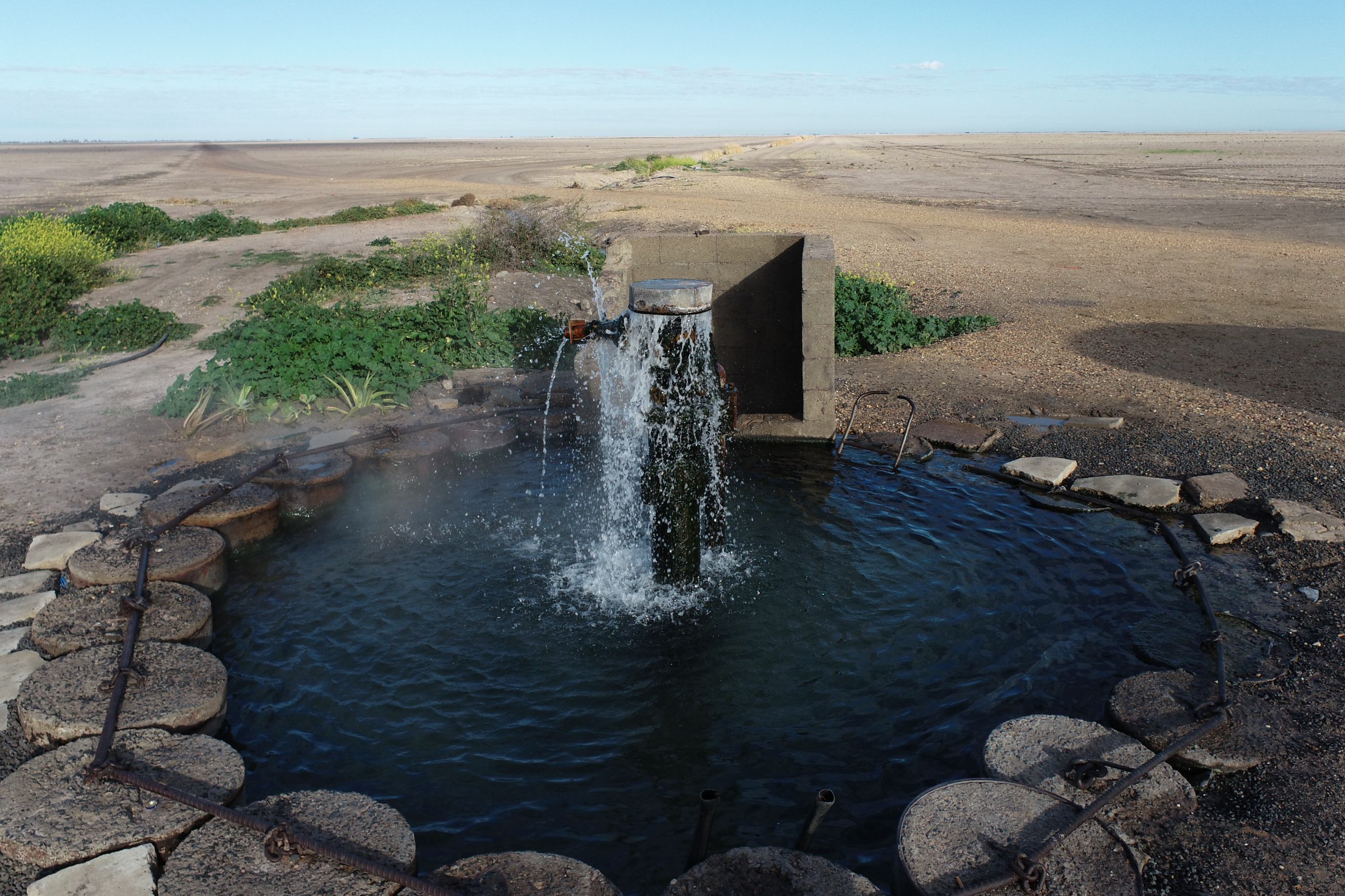
Topic image:Gamilaroi Country–Macquarie Marshes. Aerial photo of artesian bore to be replaced and plugged under IGABDR program in 2021 south of Moree. Photo credit: Water efficiency team/DPIE (2020)Banner image:Topic image sits above Butjin Wanggal Dilly Bag Dance by Worimi artist Gerard Black. It uses symbolism to display an interconnected web and represents the interconnectedness between people and the environment.
Image source and description
Topic image:Gamilaroi Country–Macquarie Marshes. Aerial photo of artesian bore to be replaced and plugged under IGABDR program in 2021 south of Moree. Photo credit: Water efficiency team/DPIE (2020)Banner image:Topic image sits above Butjin Wanggal Dilly Bag Dance by Worimi artist Gerard Black. It uses symbolism to display an interconnected web and represents the interconnectedness between people and the environment.
Groundwater
Groundwater is a valuable resource in NSW. It supports a wide range of plants and animals in many diverse environments, and can be extracted for use in agriculture, industry and households.
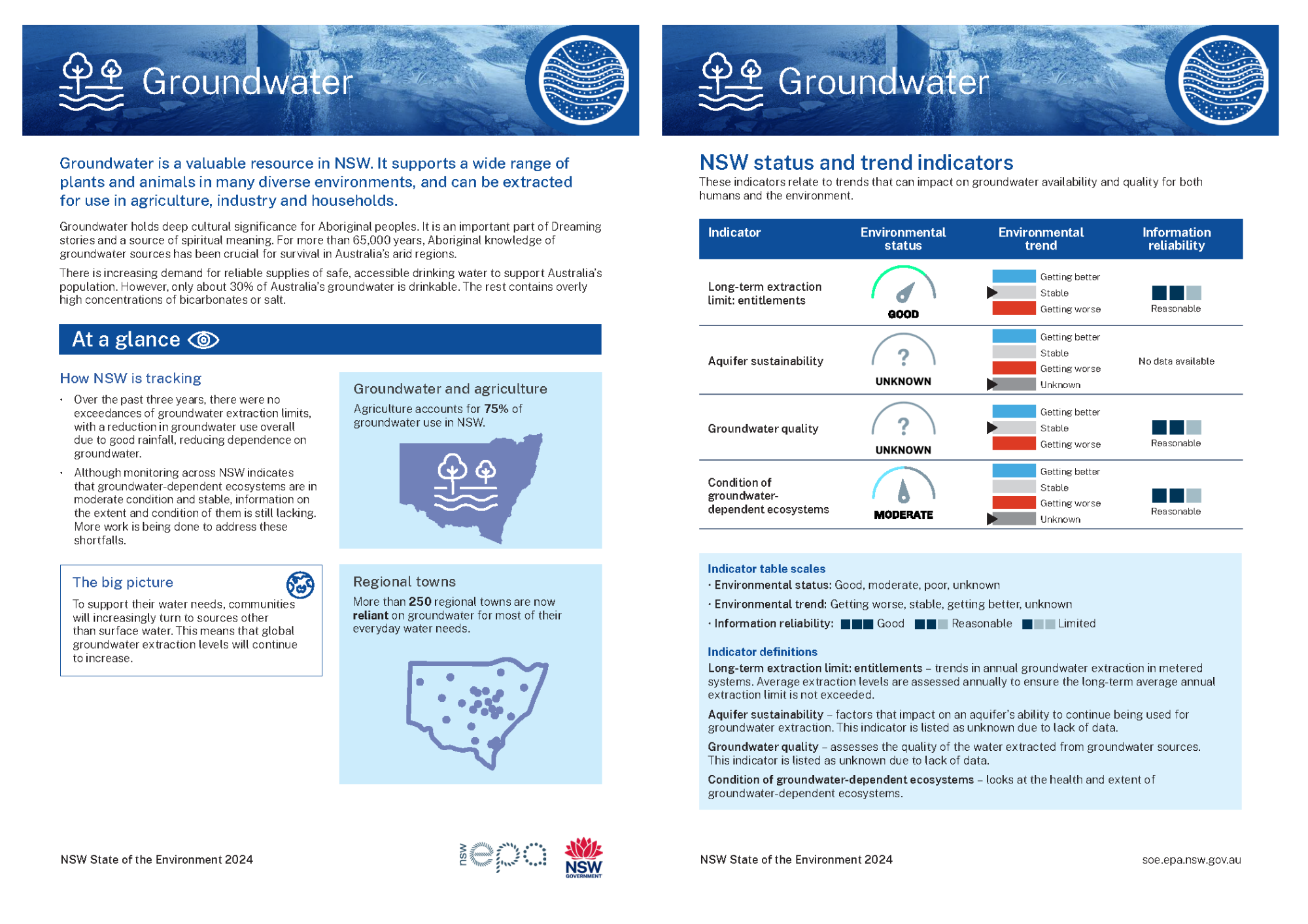
Topic report card
Read a two-page summary of the Groundwater topic (PDF 236KB).
Overview
Groundwater is an invisible but vital resource that supports unique ecosystems, industries and many rural towns.
Groundwater holds deep cultural significance for Aboriginal peoples. For more than 65,000 years, Aboriginal knowledge of groundwater sources has been crucial for survival in Australia’s arid regions.
Groundwater that is suitable for drinking and other human uses is limited. Not all groundwater is accessible or usable ().
Only about 30% of Australia’s groundwater is drinkable, with the remainder containing dissolved minerals, such as sodium or magnesium bicarbonates and, less commonly, sodium chloride (salt).
There is increasing demand for reliable supplies of safe, accessible drinking water to support Australia’s growing population.
The rate of groundwater extraction in NSW has fallen over the past three years due to increased rainfall, with no groundwater source exceeding limits set for sustainability. Extraction has declined as more surface water and runoff has been used to meet water needs, reducing dependence on groundwater.
Groundwater conditions remain difficult to monitor at a statewide level. While there is some monitoring of groundwater salinity and an awareness of emerging contamination issues (for example, PFAS), there is no comprehensive statewide assessment for groundwater quality.
Similarly, the condition of groundwater-dependent ecosystems is available only for limited areas across the State. However, a comprehensive mapping of groundwater-dependent ecosystems has been done, with sites categorised based on their ecological value to help prioritise planning and management.
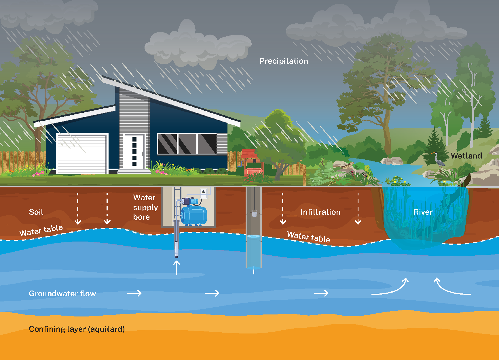
What is groundwater
Groundwater is found beneath the ground in aquifers. Aquifers are layers of saturated rock or sediments (such as sand or gravel) that store water in rock cracks and sediment spaces (pores). It has a permeability that allows water to flow through it easily.
NSW has more than 500 groundwater sources, with an estimated 5,110 million megalitres (or 5,110,000 gigalitres) of groundwater stored in aquifers across NSW. Most of this is contained in confined aquifers ().
Confined aquifers are those fully underground and contained between aquitards (described below). Water stored within confined aquifers is pressurised, causing the water level to rise above the saturated zone.
Unconfined aquifers (such as the one shown in Image W2.1) are exposed at the surface, with the top of the saturated zone represented by the water table. The water table can rise and fall as water moves into and out of the aquifer.
Image W2.1: Conceptual model of groundwater occurrence
Formations containing groundwater are characterised by:
- Porosity – the measure of the total volume of rock or sediment that is open space (expressed in the percentage of the formation volume). It indicates the maximum volume that is available to hold water underground.
- Permeability – the capacity that an aquifer has to transmit water (expressed in metres per day). It varies greatly and depends on the shape and connectedness of the pores in the aquifer. It is not a measure of the speed at which groundwater flows.
- Storage – the volume of water per square metre that is released from an aquifer for each drop in water level of 1 metre.
An aquitard (see Image W2.1) is a body of rock or sediments with low permeability (for example, clay or poorly fractured rock). This means only a relatively small quantity of water can move through an aquitard.
The difference in storage between unconfined and confined is significant. The impact of taking water from a confined aquifer is greater than taking the same amount of water from an unconfined aquifer.
The impacts of pumping from an unconfined aquifer are generally local – probably confined to a single land holding. By contrast, the impact on a confined aquifer will extend, in most cases, onto adjacent properties, which in a rural setting could be many kilometres. This is why groundwater must be managed as if it is a ‘common good’ not a ‘private good’.
Groundwater can return to the surface via:
- baseflow, which adds water to a river channel
- water flowing to the surface through a spring
- pumping groundwater up from an aquifer.
Recharge rate is the rate at which an aquifer is replenished. This rate is impacted by:
- the type of aquifer
- the amount and intensity of rainfall
- soil and vegetation types
- geology
- topography
- land use.
Recharge rates cannot be directly measured and are highly variable (). This means it is very difficult to determine the amount of recharge, particularly in the arid and semi-arid areas of western NSW.
Groundwater yields differ () based on the type of groundwater system:
- Unconsolidated sediments in alluvial floodplains and coastal sand beds provide most groundwater supplies. This is because their greater porosity makes them more permeable.
- Consolidated porous rocks in sedimentary basins have varying groundwater yields and salinity, ranging from freshwater in coastal sand dunes to higher salinity groundwater in some coal basins.
- Fractured rock groundwater systems typically have low groundwater yields. Fractured basalt rocks on the north coast of NSW are an exception.
Connectivity of surface and groundwater
Groundwater systems often connect to surface water systems and water is transferred between them. Removal of large amounts of groundwater will reduce the water it provides to connected surface waters. This includes water in springs, and baseflow – flow of water from an aquifer into a river.
Similarly, removing large amounts surface water reduces the water available to recharge the aquifer and hence the amount of water in the aquifer.
Groundwater recharge occurs when surface water in the environment soaks through the soil to the water table. Recharge is difficult to measure accurately because it can’t be observed directly and is impacted by many factors, such as rainfall, soil type, type and extent of vegetation, urban development and water table depth.
Where groundwater discharges to the surface it supports a wide variety of ecosystems. Plants and animals can also directly access the water, often from subsurface water just above the water table and groundwater-fed springs.
These are referred to as groundwater-dependent ecosystems. They support many unique floral species, including 69 threatened plant types in NSW and the animals that depend on these plants ().
Aboriginal sacred sites and culturally important sites on land are also often linked to groundwater-dependent ecosystems. These sites include trees, bush foods and soaks – where groundwater can be collected by digging down less than a metre.
The significance of groundwater for Aboriginal peoples
Groundwater holds deep cultural significance for Aboriginal peoples.
For more than 65,000 years, Aboriginal knowledge of groundwater sources has been crucial for survival in Australia’s arid regions. Passed down through generations, traditional knowledges emphasise not just finding water, but also managing it sustainably and protecting it ().
It is an important part of Dreaming stories and a source of spiritual meaning (). For example, accessing groundwater deep within the earth links Aboriginal people to deep time (). There is an understanding that groundwater is intimately connected with surface waters, the lands and the sky ().
Groundwater-dependent ecosystems
Groundwater-dependent ecosystems require access to groundwater to maintain a diversity of species and ecological processes.
These ecosystems are found in a wide range of environments with biological and physical characteristics that make them uniquely different from other ecosystems ().
Groundwater-dependent ecosystems are grouped into three broad types:
- subterranean – those in aquifers and caves
- aquatic – where groundwater meets surface (such as river and stream baseflow)
- terrestrial vegetation – those dependent on the subsurface presence of groundwater ().
Terrestrial vegetation and wetland across more than 6.5 million hectares of NSW (about 8% of the land surface) have been identified as having a high probability of being groundwater-dependent ().
How groundwater is used
In NSW, groundwater is used for agriculture, mining, town water supplies and domestic use (see Figure W2.1).
Figure W2.1: Groundwater extraction in NSW by major users, 2022
Notes:
Agriculture = 75%, Industry = 15%, Domestic = 10%
Agriculture remains the dominant use for groundwater in NSW, accounting for 75% of the State’s usage in the past eight years (). Water from high-quality alluvial groundwater systems supports highly productive food and fibre industries.
Groundwater is also used in some mining operations, such as for dust control. Sometimes mining cannot proceed until hazardous groundwater is controlled, usually by removal and disposal.
Groundwater systems are used to supplement or replace surface water supplies when surface water is less available. During drought, this provides a buffer for agricultural businesses, businesses that depend on them, and regional economies in general, and ensures faster recovery.
Some groundwater is set aside as water for the environment through water sharing rules and water licences. Water that is earmarked for the environment cannot be taken or used for any other purpose ().
In NSW, groundwater-related activities directly generate close to $1 billion (). It’s also an important source for communities’ water supply, especially during droughts.
More than 250 regional towns (with a combined population of nearly 300,000) depend on groundwater – either completely or partially – for farming, irrigation and domestic use ().
Managing groundwater
Aboriginal knowledge and cultural practice and Lore traditionally ensured sustainable groundwater management. Aboriginal loss of access to Country has resulted in significant impacts to water quality and supply.
Historically, surface water and groundwater have been managed as two independent resources.
However, where they are interconnected, activities that impact one are likely to impact the other – often with a significant time delay.
Reductions in aquifer flow by heavy extraction may not be noticeable immediately. The effects may be visible within days or not be visible for decades. The timeframe depends on the aquifer type, extraction depth and distance between the bores and the river.
Heavy pumping of groundwater can reduce or eliminate the flow in a connected river during drought times. This occurs because the extracted groundwater would have otherwise moved from the aquifer into the surface water channel as baseflow.
Extraction of large amounts of water from rivers can also reduce groundwater recharge. This occurs when the river height is no longer high enough to cause downward flow or when the height of the nearby water table has been reduced.
Water-management mechanisms that recognise connectivity
Modern water-management mechanisms are moving towards overseeing these resources in a way that recognises the close relationship of groundwater and surface water, such as the connectivity between rivers and aquifers.
For example, Action 1.2 under Strategic Priority 1 of the NSW Groundwater Strategy is to improve protection of groundwater-dependent ecosystems and the baseflow to streams. The action identifies the need to develop a framework for protecting these assets ().
The Water Management Act 2000 is the primary tool for the management of surface and groundwater resources in NSW. Water sharing plans apply to all surface and groundwater sources in NSW.
The purpose of a water sharing plan is to:
- define the volume of water that can be extracted from a groundwater system and share it among groundwater users, which include the environment
- give water users information about when and how water is available for use
- protect the environmental health of a water source
- ensure the water source is sustainable in the long term.
Together with other water policies, these water sharing plans manage this interconnected relationship through:
- rules for shared water resources
- setback distances for groundwater extraction works from highly connected surface waters and groundwater-dependent ecosystems
- approval conditions that may adjust rates of groundwater extraction in certain circumstances ().
Applications for new production bores undergo hydrogeological impact assessments where relevant. This includes consideration of impacts on surface water connections and groundwater-dependent ecosystems.
Where a hydrogeological impact assessment has been performed, actions to mitigate these impacts may be recommended. They include extraction limits and construction conditions.
Tracking extraction levels
Groundwater extraction is managed to protect the availability and long-term sustainability of groundwater resources ().
The Water Management Act 2000 and the Murray-Darling Basin Plan set rules and limits for how much groundwater can be taken, while ensuring that the plants and animals that rely on groundwater are not adversely impacted ().
Water users can only extract a limited amount from a groundwater source.
Average extraction levels are assessed annually to ensure the long-term average annual extraction limit is not exceeded ().
If this is exceeded, groundwater access may be temporarily restricted by reducing the amount of water going into accounts (known as an allocation or available water determination) or reducing the amount of water that can be taken or traded from accounts (known as a maximum water account debit).
Managing groundwater extraction is challenging and complex. This is mainly because:
- gathering data and monitoring activities is more difficult underground than on the surface ()
- each of the many aquifers in NSW is unique in composition, size and the many factors that determine how they function. This means they cannot be managed the same way.
The State’s groundwater management framework is made up of a combination of legislation and policies that govern the use and protection of groundwater resources, and the activities that may have an impact on these resources (see Table W2.1).
Table W2.1: Current legislation and policies relevant to groundwater management
| Legislation or policy | Summary |
|---|---|
| Protection of the Environment Operations Act 1997 | Manages contamination at a point source (single, identifiable location of contamination, such as a pipe) and protects groundwater quality in NSW. |
| Water Management Act 2000 | Establishes principles to manage groundwater resources in NSW. |
| Murray-Darling Basin Plan | Sets the amount of water that can be taken from the Murray-Darling Basin while leaving enough volume to maintain the environmental health of the river. |
| Non-urban water metering framework | Outlines regulations to enforce metering consistently across the State, inclusive of reporting of metered usage. |
| NSW Aquifer Interference Policy | Sets out impact assessment requirements and limits for aquifer interference activities in NSW. |
| NSW Groundwater Strategy | Sets out a statewide 20-year strategy to protect groundwater resources and dependent ecosystems, support water-dependent aspirations of Aboriginal people, improve water resilience for urban populations and better improve groundwater management and investment decisions. |
| Water sharing plans | Outlines water sharing processes and operational rules for water users and the environment in NSW. |
Notes:
See the Responses section for more information about how protection of native animals is managed in NSW.
Related topics: | |
Status and trends
Groundwater indicators
Four indicators are used to assess groundwater status and trends in NSW (see Table W2.2). These indicators relate to trends that can impact groundwater availability and quality for both humans and the environment.
The indicators are:
- Long-term extraction limit: exceedances reports on trends in annual groundwater extraction in metered systems (see Long-term extraction limit: exceedences).
- Aquifer sustainability looks at factors that impact an aquifer’s ability to continue being used for groundwater extraction. This indicator is listed as unknown due to lack of data. Further information will be required to assess status and trends in future reports (see Aquifer sustainability).
- Groundwater quality assesses the quality of the water extracted from groundwater sources. This indicator is listed as unknown due to lack of data. Further information will be required to assess status and trends in future reports (see Groundwater quality).
- Condition of groundwater-dependent ecosystems looks at the health and extent of groundwater-dependent ecosystems (see Condition of groundwater-dependent ecosystems).
Table W2.2: Groundwater indicators
| Indicator | Environmental status | Environmental trend | Information reliability |
|---|---|---|---|
| Long-term extraction limit: exceedences | Stable*** | Reasonable | |
| Aquifer sustainability* | Unknown | n/a | |
| Groundwater quality** | Stable | Reasonable | |
| Condition of groundwater-dependent ecosystems | Unknown | Reasonable |
Notes:
* The previous indicator for ‘aquifer sustainability’ was changed from ‘aquifer integrity’ to better reflect data informing the indicator.
** Not enough data exists to indicate a statewide trend (DCCEEW n.d.-f).
***Short-term improvements have been seen in the current reporting period coinciding with prevailing wet weather conditions. Long-term trends remain stable.
Indicator table scales:
- Environmental status: Good, moderate, poor, unknown
- Environmental trend: Getting better, stable, getting worse
- Information reliability: Good, reasonable, limited, n/a (no data available)
See Indicator guide to learn how terms and symbols are defined.
Long-term extraction limit: exceedences
Water Sharing Plans outline the amount of groundwater available for extraction from a groundwater source and how it is to be shared between water users.
These users include access licence holders. A water access licence allows the licence holder to take water from a groundwater source.
Each water year commences on 1 July. At the start of each water year a determination is made regarding the water available in each groundwater source. This allows for allocation to licence holders.
Allocations can be varied from year to year based on historic extraction patterns. Before the start of each water year, the total extraction in a groundwater source is reviewed by checking extraction data recorded by water meters at bores. Total extraction should be within the plan's extraction limit.
If extraction in a groundwater source is close to or exceeds the plan’s limit, it may trigger a reduced available water determination. Managing the extraction of groundwater in this way ensures it is available now and into the future.
Extraction
Agriculture remains the dominant use for groundwater in NSW, accounting for 75% or more of take. Extraction by industries (including mining) accounts for 15%, while domestic and town water supplies use 10% ().
Groundwater extraction often reflects weather patterns, with higher levels of extraction in drier years. The years 2021 to 2023 saw above-average levels of state-averaged annual rainfall in NSW, with some of the highest levels on record (since 1900) ().
On average, groundwater extraction decreased or remained mostly stable across metered systems during that time (see Figure W2.2).
Figure W2.2: Annual groundwater extraction (GL) from metered systems by type, 2001–02 to 2022–23
Notes:
LTAAEL = Long-Term Average Annual Extraction Limits. The change in LTAAELs in 2020–21 is due to updates to the relevant water sharing plans.
During times of drought, groundwater can provide up to 70% of the total water usage by agriculture.
Between 2017–18 and 2019–20, NSW experienced an extended, severe drought. Conditions were hotter and drier than any in the previous 120 years (). In that period, groundwater extraction levels in NSW increased significantly to reflect this (see Figure W2.3).
Figure W2.3: Annual total metered groundwater extraction, 2001–02 to 2022–23
On average, annual groundwater extraction levels decreased each year between 2019–20 and 2022–23. This reflects the higher-than-average patterns of rainfall experienced across the State during that period.
Since 2021, the overall level of groundwater extracted from all metered groundwater sources in NSW is lower than the cumulative sustainable extraction limits. This is likely because higher-than-average rainfall levels have reduced the need to pump groundwater.
Aquifer sustainability
Aquifer sustainability in NSW has remained stable. This is largely the result of the wetter than average years in this reporting period.
The sustainability of an aquifer is impacted by several factors. These include extraction activities and the aquifer’s structure and water quality.
Since the State of the Environment 2021 (), aquifer sustainability in NSW has remained stable. This is largely the result of the wetter than average years in this period, as reported above.
Sustainable yield
Groundwater extraction across NSW is currently within sustainable yield limits.
To protect future groundwater availability within aquifers, sustainable yields are determined for groundwater sources. These are called Long-Term Annual Average Extraction Limits (LTAAELs).
The LTAAEL is the amount of water able to be taken from a groundwater source over a specified timeframe that allows for acceptable levels of stress and protects dependent economic, social and environmental values.
LTAAELs are different for each water source. These values are determined using different methods, depending on the groundwater source. They include:
- use of numerical models
- estimations of recharge
- analysis of the physical parameters of the groundwater source.
Between 2021 and 2024, there was no over-extraction of surface groundwater in any groundwater source relative to the LTAAEL set in each area (see Map W2.1). Only one area had an average extraction above 60% of its LTAAEL: the Namoi Valley Zone 5 area (orange section of Map W2.1).
Map W2.1: Groundwater extraction per water source relative to LTAAELs (%), 2021–22 to 2023–24
Notes:
Groundwater extraction as a percentage of the Long Term Annual Average Extraction Limit (LTAAEL) of each water source was calculated using the average extraction of groundwater across period of three financial years, 2021–22, 2022–23 and 2023–24.
Water accounting years are aligned to financial years.
This map and analysis is for surface groundwater sources.
Groundwater extraction over the past three years has not exceeded groundwater extraction limits, in part due to good rainfall across the State.
Map W2.2 shows the change in the percentage of groundwater extraction relative to the LTAAEL for each water source between 2017–21 and 2021–24. There were declines in relative LTAAEL extraction in all water sources.
Map W2.2: Groundwater extraction per water source relative to LTAAELs (%), 2017–21 to 2021–24
Notes:
Change in groundwater extraction as a percentage of the Long-Term Annual Average Extraction Limit (LTAAEL) of each water source was calculated using the difference between average extraction of groundwater across 2017–18, 2018–19, 2019–20 and 2020–21 (the period shown in the previous State of the Environment 2021) and the period of the three most recent financial years, 2021–22, 2022–23 and 2023–24.
For example, between 2017–21 the Liverpool Ranges Basalt water source had an average of 85% LTAAEL extraction, while in 2021–24, only 1% of its LTAAEL was extracted, meaning there was a change in extraction relative to the LTAAEL of 84% (not an 84% reduction in extraction).
Water accounting years are aligned to financial years.
This map and analysis is for surface groundwater sources.
Structural sustainability
While an aquifer’s geology does not change significantly over time, some extraction activities can impact the aquifer’s structure and reduce its storage capacity.
Groundwater fills the tiny pore spaces in and around the sediment within an aquifer. This helps it to maintain its structure and stability. If groundwater is extracted too quickly and for too long, the pore spaces can collapse. This causes sediment compaction.
When sediment compaction occurs over a large area it permanently lowers the amount of available space for groundwater storage in an aquifer.
In rare cases, compaction can also cause the land surface to sink. This is known as land subsidence or ground displacement.
Studies have been undertaken to investigate and understand the impacts of groundwater extraction on land subsidence. Data was taken from locations in the Lower Namoi groundwater source and southern inland NSW groundwater sources, including the Murray, Murrumbidgee and Lachlan ().
This data included surveyed benchmarks, historical groundwater levels and remote sensing radar imagery (Interferometric Synthetic Aperture Radar, or InSAR).
In the Lower Namoi it was found that land subsidence was the result of a natural and periodic process of clay shrinking and swelling. In the southern inland areas, groundwater extraction was found to contribute to land subsidence in some isolated locations.
These studies will be the benchmark for future studies into aquifer integrity and land subsidence in NSW ().
Groundwater quality
There is limited in-depth knowledge of groundwater quality across NSW.
Current monitoring activities provide only a ‘picture in time’ of water quality and cannot provide information regarding trends over time.
Water quality in the context of the NSW resource management framework refers essentially to the level of salt contained in groundwater. Water quality ranges from fresh to saline.
Groundwater is considered fresh when it holds low salt levels and can be used for town water, stock and domestic supply, or for commercial purposes, such as farming and irrigation.
Many factors, usually related to human activities, impact groundwater quality. The quality affects the people, plants and animals that depend on groundwater systems.
Groundwater quality is degraded by:
- dissolved salts entering groundwater due to mineral weathering in the surrounding aquifer
- pollutants entering groundwater with surface waters in recharge areas.
For more information, see the Australian Government’s guidelines (PDF 1.36MB) for protecting the quality of groundwater (Australian Government 2013); and its online water quality management framework ().
Monitoring water quality
A statewide groundwater sampling program was undertaken in 2021 to assess groundwater quality across many NSW sites. During this exercise 588 bores at more than 332 locations were visited, with 957 samples taken ().
Localised baseline datasets exist for groundwater quality in three high-extraction groundwater sources in NSW: the Lower Naomi, Lower Murray and Lower Murrumbidgee. An analysis of the data from these locations indicates there is no change in water quality associated with beneficial groundwater extraction ().
The limited number of sites regularly monitored over time means there is insufficient data to represent the impacts of groundwater extraction on water quality statewide.
Saline intrusion
The movement of saltwater into freshwater aquifers is known as saline intrusion. While it can be a natural process, the intrusion of saltwater into aquifers has detrimental effects on extracted groundwater quality and related uses.
There can be a high risk of saline intrusion where:
- groundwater extraction is high
- the aquifer is overlain or underlain by saline aquifers
- the aquifer is near the coast.
Water quality in coastal areas of NSW is at particular risk of saline intrusion from seawater. Bore-monitoring sites have been constructed in some areas to monitor for changes. Some bores use automatic data loggers to collect hourly salinity data and include specific triggers linked to response procedures.
Seawater is not the only cause of high salinity. Studies of high-volume groundwater extraction in inland alluvial aquifers have identified localised areas of water quality decline due to salinity. This decline is associated with changing groundwater flow patterns due to the extraction. Strategies are being developed to address these risks.
Contamination
Groundwater can become contaminated by sources of pollution, including:
- industrial sites
- fuel storage tanks
- septic systems
- landfill sites.
There is no statewide comprehensive record of groundwater contamination, though there are localised monitoring projects.
Groundwater contamination can cause significant animal and human health risks. In some cases, it can render a groundwater source unusable.
Pollutants can move over a large area, including deep underground. Leakage of pollutants into aquifers poses a particular risk to water quality.
It is extremely difficult and expensive to remediate contaminated groundwater sources.
An emerging groundwater quality issue in NSW is contamination by PFAS (per- and poly-fluoroalkyl substances).
Groundwater contamination has been reported in a number of locations across NSW as a legacy of the use of foams containing PFAS for firefighting until 2007. The chemical characteristics of PFAS make them highly resistant to degradation ().
See the Responses section for more information about how the NSW Environment Protection Authroity (EPA) is managing PFAS.
Condition of groundwater-dependent ecosystems
Groundwater-dependent ecosystems (GDEs) require access to groundwater to maintain a diversity of species and ecological processes.
GDEs are found in a wide range of environments with biological and physical characteristics that make them distinct from other ecosystems ().
GDEs are grouped into three broad types:
- subterranean – those in aquifers (stygofauna) and caves
- aquatic – where groundwater meets surface-expressed groundwater or aquatic ecosystems (for example, river baseflow)
- terrestrial vegetation – those dependent on the subsurface presence of groundwater ().
In NSW, examples of GDEs include:
- aquifer ecosystems
- cave and karst ecosystems
- river and stream baseflow ecosystems
- groundwater-dependent terrestrial vegetation (phreatophytes)
- groundwater-dependent wetlands
- Great Artesian Basin springs
- estuarine and near-shore marine ecosystems ().
Terrestrial vegetation and wetland across more than 6.5 million hectares of NSW (about 8% of the land surface) have been identified as having a high probability of being groundwater-dependent () (see Map W2.3).
Information on the condition of all GDEs in NSW is not comprehensive.
However, relative ecological value of GDEs has been assigned to help inform management actions. These values are based on the High Ecological Value Aquatic Ecosystems approach ().
Understanding the location, extent and condition of groundwater-dependent ecosystems is vital for planning and management of surface water and groundwater. This information allows resource management decisions to consider the needs of the ecosystems and how to protect them.
Map W2.3: Location of groundwater-dependent ecosystems in NSW
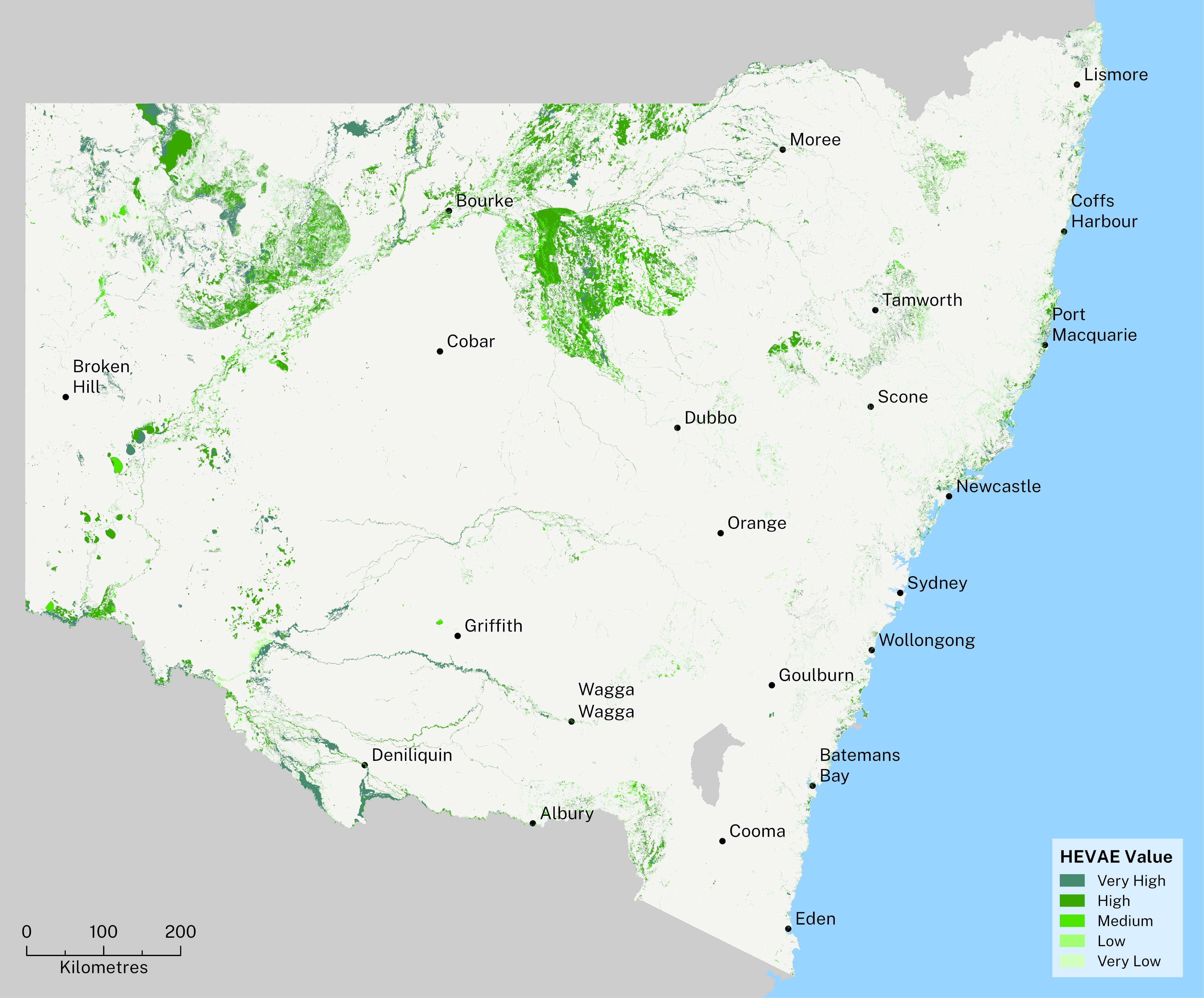
Notes:
Map created using Spatial Layer of HEVAE Vegetation Groundwater Dependent Ecosystems Value in NSW.
Access the interactive version of this map.
Pressures and impacts
High demand
It’s not sustainable to consistently extract groundwater faster than it can recharge. This removes it as a resource and has permanent consequences for dependent ecosystems.
In NSW, 54 groundwater sources are fully committed. This means if each entitlement share was assigned a value of 1 megalitre, the sum of the entitlement shares plus unlicensed rights to take groundwater would meet or exceed the groundwater source extraction limit ().
While the groundwater Available Water Determination (AWD) mechanism ensures the extraction limit is not exceeded, this indicates there is a strong demand for groundwater and a need to ensure its sustainability.
Development
The volume and quality of groundwater is threatened by land clearing, diverted runoff and contaminants.
Urbanisation
Rainfall on hard surfaces is often channelled into drains, rather than contributing to soil moisture. This can reduce the potential for recharge to the local water table.
Exposure to contaminants can pose direct short- and long-term threats to the ecology of groundwater-dependent ecosystems. Contaminants might include:
- nutrients from fertilisers and septic tank effluent
- agricultural pesticides
- metals and hydrocarbons from commercial and urban land uses (for example, leakage from underground petroleum storage systems).
Land use changes and vegetation clearing
Intensive agriculture and land clearing can increase surface water runoff and drainage erosion. This, in turn, can impact the water table through reduced recharge and increased aquifer drainage.
Activities that can impact the integrity of an aquifer are known as aquifer interference activities (). They can include anything that:
- penetrates an aquifer
- interferes with groundwater in an aquifer
- changes or obstructs groundwater flow in an aquifer
- takes groundwater from an aquifer
- disposes of water taken from an aquifer.
See the topic for more information.
Poor water quality
Poor water quality can negatively impact people and the environment.
Factors affecting groundwater quality and availability can be naturally occurring (seasonal weather, natural distribution of salts) but also affected by disruptions, including:
- excessive demand and extraction
- changes in land use
- changes in climate conditions
- pathogens
- chemical contamination and microbiological contamination
- lack of protection of aquifer recharge areas
- lack of local planning rules and borefield capture zone protection for town water supply borefields.
Chemical contamination of groundwater can reduce the value for water users and even prevent some types of water use. It also increases water treatment costs.
Once contaminated, an aquifer is extremely difficult and expensive to restore ().
Cultural heritage
Groundwater is a vital resource for many remote and arid Aboriginal communities. Low availability and poor quality are serious issues in many areas (; ).
Competition from agricultural and mining activities and the logistical challenges of accessing water in remote areas contributes to the risk of insufficient water quantity and quality for Aboriginal people (; ).
The low quality of the groundwater in bores can have serious health consequences for communities that depend on them ().
A larger percentage of the population in remote and arid regions of NSW are Aboriginal. This means they are disproportionately impacted where groundwater availability is reduced due to competition from agricultural use and mining ().
Groundwater decline impacts extend beyond environmental values. They also pose a significant threat to cultural heritage.
Groundwater-fed ecosystems may include sacred sites with special trees and bush foods. Lowering the water table means these sites may be destroyed, jeopardising the cultural traditions that depend on them. For example, a scarred tree, a living testament to cultural history, might rely on groundwater to survive.
Dreaming tracks also rely on water sources for navigation and cultural knowledge. Protecting these cultural values means protecting the groundwater itself ().
Informed management of surface water, which can directly impact groundwater supplies, is crucial (Caron et al. 2021). An example of this is the Boobera Lagoon in Moree Plains Shire. The loss of Aboriginal access and management disrupted the delicate balance between surface and groundwater in the lagoon, resulting in a decline in water quality ().
Climate change
Climate change is expected to directly affect groundwater resources. Impacts may include:
- an increase in groundwater extraction due to decreased surface water availability
- changes to groundwater recharge ()
- changes to the relative pressure between fresh and saline water, potentially affecting the distribution of fresh water in aquifers ().
For groundwater recharge, it is important to distinguish shallow, unconfined aquifers from deeper, semi-confined to confined aquifers. Their recharge processes are different, and the timing of an effect on recharge variation will also be largely different.
The main mechanisms of groundwater recharge of unconfined aquifers (or water table aquifers) include:
- flow from other aquifers
- rainfall infiltration
- river losses to the underlying aquifer
- aquifer recharge during floods.
Semi-confined and confined aquifers are generally recharged where the aquifer materials are exposed to the surface. Recharge to confined aquifers may take decades or even hundreds of years.
Climate change may increase the demand for groundwater due to reduced access to surface water.
Changes in surface water characteristics and rainfall frequency and intensity due to climate change may also influence groundwater quality and recharge.
Climate modelling predicts an increase in the frequency and intensity of extreme rainfall events ().
While rainfall (and the associated stream flows and flooding) is a major source of recharge for many groundwater systems, more rain may not always mean greater recharge.
A 10-year study conducted in the arid zones of western NSW has shown that during high-intensity rainfall events, water is often lost through runoff before it can soak into aquifers. This shows that the relationship between rainfall and aquifer recharge is far more complex than previously thought, and predictive modelling for recharge may need to be re-examined ().
See the topic for more information.
Extreme weather events
Groundwater is managed using long-term averages. This approach ensures groundwater systems, with their large storage capacities, provide a buffer to supply water in times of drought.
Climate variations affect how much groundwater people use. During droughts, groundwater extraction may increase to offset the low availability of surface water. This results in declining groundwater levels ().
Rising sea levels
Rising sea levels have the potential to increase the salinity of land and coastal aquifers This results from increased pressure of the saline water against the freshwater groundwater flow.
See the topic for more information.
Knowledge gaps
Connections
Connectivity, as it relates to groundwater, refers to the degree of hydraulic interaction between:
- different aquifers
- different parts of the same aquifer
- groundwater and surface water systems.
These connections are generally not well understood across NSW.
Where connectivity between water resources is high, water transfers readily. This means that extracting water from one source may also impact groundwater resources in a connected area.
Recharge
Recharge occurs when surface water in the environment soaks through the soil to the water table. Recharge is difficult to measure accurately. This is because it cannot be observed directly and is impacted by many factors, such as rainfall rates, soil type, vegetation cover and type, urban development and water table depth.
As reliance on groundwater increases, so does the importance of understanding aquifer recharge and the factors that impact it. Current understanding of recharge mechanisms and rates is poor.
Responses
Increasing recharge
In February 2022, the NSW Government published reports on how groundwater levels have changed since monitoring began in the 1970s and 1980s across 29 inland alluvial groundwater systems. Department hydrogeologists reviewed and analysed data from 1,300 groundwater monitoring sites.
They looked at how deep the groundwater levels fall during the summer irrigation season and the level to which they recover when the bore pumps are turned off during winter.
The report found that:
- Groundwater levels have generally fluctuated within acceptable levels of decline and recovery. In some localities, with concentrated areas of pumping, groundwater levels are not able to fully recover before the following irrigation season starts.
- Lower Gwydir, Lower Namoi and Upper Lachlan alluvial groundwater sources were identified as at most risk. Local management solutions have been put in place and work is underway to achieve the NSW Groundwater Strategy objective to manage these groundwater systems sustainably.
- There may be opportunities to enhance groundwater recharge and then contribute to increased storage. DCCEEW is working on a policy that will allow ‘artificial’ groundwater recharge, such as managed aquifer recharge.
Adapting to climate change
The effect of climate change on groundwater availability in NSW is largely unknown.
The NSW Groundwater Strategy will address how climate change is expected to influence groundwater availability and management, and inform the development of adaptation tools.
A program of work is under development in line with the NSW Groundwater Strategy Implementation Plan 2023 to 25. It will look at better characterising current groundwater recharge mechanisms and the impact of a future climate on groundwater availability.
Groundwater recharge is a slow process in most aquifers. The timeline of impact to the availability of water depends on the type of aquifer. For instance, a deep confined aquifer won’t feel the impact of a reduced recharge for hundreds of years.
The program of work is expected to also look at groundwater quality changes, usage behaviours and management options.
Managing groundwater quality
A baseline of groundwater quality characterisation has been collected over the past few years. This is the first statewide program of groundwater quality status in NSW.
In line with the NSW Groundwater Strategy, the NSW Government is preparing a groundwater quality monitoring strategy and a program of monitoring.
The program will set the frequency and locations of monitoring using the:
- risk exposure of groundwater systems
- speed of potential groundwater quality changes.
Groundwater contamination via chemical release remains largely controlled under the regulation of the EPA.
An emerging groundwater quality issue in NSW is contamination by PFAS (per- and poly-fluoroalkyl substances).
Various levels of groundwater contamination have been reported in several locations across NSW as a legacy of the use of foams containing PFAS for firefighting until 2007. The chemical characteristics of PFAS make them highly resistant to degradation ().
The EPA leads the NSW Government PFAS Investigation Program. This program assesses legacy sites where it is likely that large quantities of PFAS have been used.
See the Australian Government website for more information about the PFAS National Environment Management Plan.
Protecting ecosystems
Knowledge of groundwater-dependent ecosystems in NSW has improved. There is still uncertainty around their extent, health and ability to respond to variations in groundwater availability.
The NSW Government implemented the Groundwater dependent ecosystems program to improve understanding of these ecosystems.
Research projects are currently being undertaken to better understand how groundwater-dependent ecosystems respond to variations in groundwater levels, and to allow for better detection of groundwater-reliant vegetation ().
These projects include:
- evaluation of vegetation health with groundwater level changes using remote sensing indices and field vegetation health indicators
- establishing the links between groundwater ecosystem health, groundwater-dependent vegetation and wetland health use in the Murray–Darling Basin
- using eDNA in groundwater to detect tree water use
- predicting the impacts of groundwater drawdown on groundwater ecosystems
- re-analysis of groundwater health in alluvial aquifers in the Murray–Darling Basin and associated thresholds for groundwater-dependent ecosystems
- establishing the links between groundwater ecosystem health, groundwater-dependent vegetation and wetland health in coastal catchments
- using a predictive stressor-response model for the ecosystem health of coastal aquifers.
Future opportunities
Listening to Aboriginal knowledges
Traditional knowledge about managing this precious resource can be valuable for informing sustainable water management practices ().
Governments at all levels need to recognise and consider these knowledges when making decisions that impact groundwater. By collaborating with Aboriginal communities and respecting their knowledge, we can ensure a future where Australia’s groundwater sustains us all ().
Unassigned water
Some groundwater sources have unassigned water available. This means that the level of commitment under basic landholder rights and access licences is less than the water sharing plan extraction limit. In these systems, the Minister for Water can make water available under a controlled allocation process.
Metered take
Most extraction from coastal groundwater sources isn’t metered. Non-metered take of groundwater also presents opportunities for better measuring, modelling and monitoring. Under the NSW Non-Urban Water Metering policy (PDF 648KB), meter coverage will improve across the State. Better monitoring of water extracted will improve understanding of how groundwater systems respond to climatic and pumping stresses.
Knowledge gaps
Under the NSW Groundwater Strategy, responses to several knowledge gaps critical to groundwater management and impact management are being developed.
The responses will:
- provide better documentation of groundwater-dependent ecosystems across NSW
- address risks to high-value groundwater-dependent ecosystems from increased constraint on a supporting aquifer
- provide better information on connectivity between surface water and groundwater.
This information will support water planning and management.
With such a strong Aboriginal connection to groundwater, NSW water managers must protect the cultural values of groundwater. This can be done by protecting groundwater quality and quantity from:
- impactful drawdown
- prolonged over-extraction
- pollution from industry, mining and agriculture.
Water quality
Groundwater quality in NSW is monitored infrequently and at few sites, though is improving. This means there is not yet sufficient data to develop a bigger picture of the impacts of groundwater extraction on water quality statewide.
Microfauna
Groundwater ecosystems contain numerous habitats that support a diverse array of microfauna biodiversity. These species, their roles and the impact of their presence, or absence, within their ecosystem are a poorly understood field of study.
Recharge
Further research is needed to inform updated prediction models to continue managing NSW groundwater resources sustainably. This is especially important as demand continues to grow and climate change impacts rainfall events.
Groundwater-dependent ecosystems
Knowledge of groundwater-dependent ecosystems in NSW is an ongoing area of improvement. The priorities set by the NSW Groundwater Strategy will further contribute to characterise all types of groundwater-dependent ecosystems and inform management responses.
Knowledge of groundwater-dependent ecosystems is still emerging. Better understanding of their location, characteristics and levels of dependency on groundwater is needed.
Little is known about plants and animals living in, or dependent on, groundwater aquifers. These knowledge gaps make it difficult to manage groundwater systems in ways that will ensure their protection.
Community education
Increasing community understanding of groundwater processes through education is part of the response to managing risks and pressures. The NSW Government has published a number of short videos to explain groundwater processes.