Summary
A return to drier weather conditions from 2017 affected the health of some wetland areas and reduced opportunities for waterbird breeding.
Why wetlands are important
The protection and sustainable management and use of wetlands is important as they provide a range of benefits to both the natural environment and people.
Wetland ecosystems support high levels of biodiversity and provide habitat for a wide range of animals and plants, including threatened species. They also play a key role in keeping the environment healthy, for example by regulating regional water cycles and climate and reducing the impact of storm damage and flooding. Wetlands are culturally significant for Aboriginal people and provide them with a strong connection to Country. They also contribute to regional economies by providing environments for commercial fisheries, grazing and tourism.
NSW indicators
| Indicator and status | Environmental trend |
Information reliability |
|
|---|---|---|---|
| Wetland extent |
|
Getting worse | ✔ |
| Wetland condition |
|
Getting worse | ✔ |
| Waterbird abundance and diversity |
|
Getting worse | ✔✔✔ |
Notes:
Terms and symbols used above are defined in .
Status and Trends
Eastern Australian Waterbird Survey data shows that the wetland area index across eastern Australia remained below the long-term median in 2020 and was the fifth-lowest since the survey began in 1983. However, the area of wetlands protected in the NSW parks estate increased between 2018 and 2020 with the addition of 209 hectares of coastal wetlands and 57,277 ha of inland wetlands.
Widespread rain and flooding during 2016 inundated many wetlands, increasing waterbird breeding. However, from 2017–19, drier conditions reduced the extent of wetland inundation and decreased waterbird breeding and waterbird abundance. Inland wetlands that have received water for the environment (held by the government and released in areas that need it) have acted as refuges for water-dependent species, including threatened frog species, during dry periods.
Spotlight figure 18 shows the percentage of coastal and inland wetland types protected in NSW reserves.
Spotlight figure 18: Percentage of coastal and inland wetland types in NSW reserves
Pressures
Water availability is the most significant pressure on the health of many wetland ecosystems. Reduced water availability can be caused by altered flows from water extraction and the building of dams, levees and diversion structures, as well as by climate change, exacerbated by extreme weather events like heatwaves and droughts.
Other pressures on wetlands include human activities which can cause physical disturbance and adversely affect wetland water quality. For example, diffuse pollution from development and other land uses can raise the levels of nutrients and sediments entering wetlands. Lake bed cropping and floodplain clearing and grazing may also disturb soil, increase nutrients and impact vegetation and seed banks. Weed and invasive species are also threatening wetlands as they can affect wetland biodiversity and habitat value, ecosystem function and water quality.
Responses
A range of NSW Government legislation, policies and programs focus on protecting wetlands. For example, the Water Management Act 2000 outlines requirements for water sharing plans for NSW rivers, one of the most important mechanisms for protecting wetlands; the NSW Wetlands Policy promotes the sustainable conservation, management and use of wetlands and the Marine Estate Management Strategy 2018–2028 and Catchment Action NSW improve and protect wetland water quality.
The Australian Clean Energy Regulator is currently finalising a method to enable land holders to claim carbon credits under the Emissions Reduction Fund for restoring some types of ‘blue carbon’ systems, specifically mangrove and saltmarsh. Any such future blue carbon projects in NSW would increase the state’s wetland areas while removing carbon from the atmosphere and mitigating climate change.
Related topics: |
Context
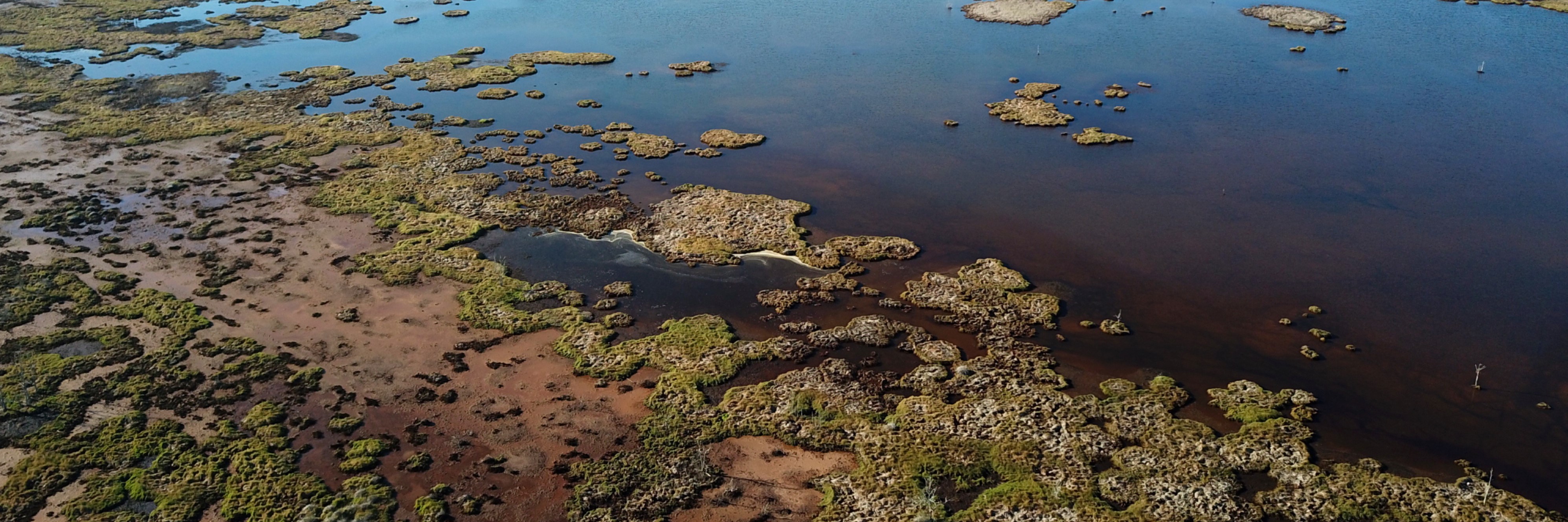
Wetlands are areas of land covered or saturated with fresh, brackish or salt water that is generally still or slow-moving. The water can also sit just below the land’s surface. An area does not need to be permanently wet to qualify as a wetland, but just wet long enough for its plants and animals to have adapted to – or even depend on – wet conditions for at least part of their life cycles.
Under the Ramsar Convention, a wide variety of natural and human-made habitat types can be classified as wetlands, including swamps, marshes, billabongs, lakes, salt marshes, mudflats, mangroves, coral reefs, fens, peat bogs and bodies of water – whether natural or artificial, permanent or temporary. Water within these areas may be static or flowing; fresh, brackish or saline; and include inland rivers and coastal or marine water to a depth of six metres at low tide.
Wetlands can be classified into five types:
- riverine wetlands, around freshwater rivers, creeks, streams and other waterways
- lacustrine wetlands, around freshwater lakes and reservoirs
- palustrine wetlands, which are inland freshwater areas with plenty of trees and other vegetation
- estuarine wetlands, around estuaries
- marine wetlands, along the coast.
Around 4.5% of NSW was mapped as wetland (excluding wetlands in coastal areas) in recent analysis which combined the 2017 Australian National Aquatic Ecosystem (ANAE) digital mapping () with NSW State Environmental Planning Policy (Coastal Management) 2018 mapping. This was roughly consistent with the earlier mapping of all NSW wetlands () which estimated their extent at approximately 5.6% of the state.
Wetland ecosystems:
- support high levels of biodiversity, providing habitat for a wide range of animals including waterbirds, fish, frogs, turtles, invertebrates and water-dependent plants
- contribute to regional economies by providing environments for commercial fisheries, grazing and tourism
- provide habitat for threatened animals including the freckled duck, Australasian bittern, green and golden bell frog and southern pygmy perch
- are home to threatened ecological communities such as coastal saltmarsh and Coolibah-Black Box Woodlands
- provide important stopover and winter habitat for many migratory birds protected under bilateral international agreements.
Wetlands also play a key role in keeping the environment healthy by:
- contributing to the cycle of gases, such as methane and carbon dioxide, and nutrients from the nonliving (abiotic) components of the biosphere to the living (biotic) components and back
- regulating regional hydrological cycles and climate
- reducing the impact of storm damage and flooding
- maintaining good water quality in rivers
- recharging groundwater.
Wetlands are culturally significant for Aboriginal people and provide them with a strong connection to Country.
Status and Trends
Long-term surveys
The basis for assessing trends in wetland extent is the long-running (1983–2020) annual Eastern Australian Waterbird Survey. In October each year, 10 aerial surveys covering areas 30 kilometres wide at every two degrees of latitude across eastern Australia monitor up to 2,000 wetlands (; ). The survey covers all waterbodies larger than one hectare, including estuaries, coastal lakes, rivers, swamps, floodplain wetlands, saline lakes, dams, reservoirs and impoundments.
The wetland area index is the sum of all the inundated wetland areas measured over the 10 aerial survey bands, rather than the actual total area, which is why it is referred to as an index. It is assumed to be a representative sample of all the wetlands and is comparable from year to year since the aerial survey bands are consistent through time.
Wetland extent and condition
The Eastern Australian Waterbird Survey data shown in Figure 18.1 shows that a reduction in wetland areas across eastern Australia in 2018–2020 to below the long-term median of 224,794 hectares. The wetland area index was 104,015 hectares in 2020, the fifth-lowest since surveys began in 1983 ().
Figure 18.1: Estimated wetland area in eastern Australia 1983–2020
Notes:
Total wetland area inundated (in hectares) for annual spring aerial survey transects. Data from annual aerial survey in 10 aerial survey bands in Eastern Australia 1983–2020.
Vegetation
A review of the literature found 16 scientific papers that reported on the field status and trends of NSW wetland vegetation between 2016 and 2021 (see Table 18.1).
Most of the research reviewed focused on the dynamics of palustrine wetlands. Studies reported the beneficial effect of a large natural flooding event in 2016 both for palustrine and estuarine wetland vegetation. Some studies also reported the benefits of environmental flows in reducing the severity and long-term detrimental impacts of drought conditions. Other studies reviewed documented evidence of resilience during dry phases by wetland types or species, while others observed transitions or reduced resilience in vegetation communities in response to changed hydrology. In addition to hydrological change, climate change, underground mining, floodplain and wetland development activities and invasion by feral animals were reported as contemporary threats to wetland conservation.
Table 18.1: Review of scientific literature on NSW wetland vegetation status and trends during 2016–2021
| Wetland type | Extent (ha)* | Status and trends observed during 2016–2021** |
|---|---|---|
| Riverine | 112,502 | Riverine estuaries have the largest intertidal wetland area in NSW (). Distribution of river cooba (Acacia stenophylla) along rivers allowed regular dispersal of seeds regardless of river level while seed dispersal of tangled lignum (Duma florulenta) depended on flooding events away from the river channel. The genetic impact of river regulation may be greater for species which occur on floodplains compared with species along river channels (). |
| Lacustrine (around freshwater lakes and reservoirs) | 459,802 | A viable wetland soil seedbank was recorded at the ephemeral Ita Lake after a 10-year dry phase indicating community resilience (). |
| Palustrine (inland freshwater areas with plenty of trees and other vegetation) | 2,905,991 | Consistent decline in the extent of non-woody wetland vegetation in the Macquarie Marshes and Barmah-Millewa observed with replacement by River Red Gum wetland (). Continued dry and wet phase responses by non-woody wetland and river red gum woodland/forest communities in the Macquarie Marshes (). Decreasing resilience (recovery to an equilibrium state after a disturbance) as distance from a water source in the Barwon-Darling River system increased: resilience diminished in a progression from river red gum forest through black box and coolibah woodland to lignum shrubland (). The condition of lignum shrubland improved with increasing environmental flow frequency at Bottle Bend Reserve on the River Murray floodplain (). Recovery was observed in the condition of river red gum forest canopy in the Murray Valley National Park during a wet phase after a drought. Foliage projective cover then decreased from wet-phase levels before stabilising during the hydro-climatically intermediate phase at levels greater than that observed during the drought (). The occurrence of a culturally significant flood-dependent species, common sneezeweed (Centipeda cunninghamii), was positively related to large-scale natural flooding and environmental flows in the floodplain wetlands of the lower Lachlan River system. The species’ occurrence was significantly higher at sites flooded at intervals between 6 and 12 months than sites unflooded for 12 months or more. Sneezeweed was more likely to occur at damp sites than dry sites (). Underground longwall mining has disrupted the hydrology of coastal upland swamp communities. Mined swamp soils dried more quickly than unmined soils after rainfall and soil moisture continued to decline following mining (). Critically endangered bog communities have been extensively damaged by feral horses in Australia’s alpine parks system (). Altered ionic composition of foliage tissue has been found in urban areas compared with natural Blue Mountains Upland Swamp communities (). Promotional effect of winter fire and slashing on a threatened grass species (Arthraxon hispidus) in sedgeland/grassland coastal wetland (). |
| Estuarine | 125,100 | Intermittently closed and open lakes and lagoons (ICOLLs) are the most common estuary type in NSW. Low levels of macrophyte occurrence in intermittent estuaries (despite suitable water quality) may be caused by catastrophic events and limited recruitment due to short periods of entrance opening (). Two estuarine lagoons with low disturbance (Durras Lake and Nadgee Lake) experienced shifts in production dominance from benthic to pelagic and back to benthic following a catastrophic reduction in water levels during drought conditions. Sustainable macrophyte beds have reappeared in these systems (). Significant increase in saltmarsh and mangrove cover during sediment deposition along the shoreline at Towamba estuary on the NSW south coast (). Transition of saltmarsh to mangrove forest observed at Homebush Bay over 18 years (2000–2018) (). |
Notes:
* The extent of riverine, lacustrine and palustrine wetlands are based on the ANAE 2017 digital map () and do not include coastal NSW (east of the Great Dividing Range). Estuarine wetland area only includes the areas of freshwater and saline intertidal wetlands mapped in State Environmental Planning Policy (Coastal Management) 2018.
** Only studies published between 2018 and 2021 were included in the review.
Waterbirds
Wetlands provide important habitat for waterbird species, allowing breeding, foraging and roosting, often in a network of sites that waterbirds are able to use during different parts of their life cycles. The presence or absence of waterbirds is useful in tracking changes in the ecosystem health of wetlands (). The Eastern Australian Waterbird Survey has demonstrated a long-term decline in waterbirds over its 1983–2020 survey period (). This program provides data for the key wetlands in 10 survey bands covering 12.3% of eastern Australia. Data on waterbirds collected by the survey includes total number of waterbirds (abundance), number of breeding species (breeding species diversity) and counts of nests and/or broods for breeding species (breeding index). To provide the measure of species diversity, waterbird abundance data is split into the following five functional groups based on the types of wetland food resources and habitats they use for feeding: ducks and small grebes, herbivores, large wading bird, piscivores (fish-eaters), and shorebirds ().
The total waterbird abundance index in 2020 declined slightly from 2017, falling from 238,603 to 162,824 waterbirds, and remained below the long-term median of 272,493 (see Figure 18.2). The abundance of all five functional waterbird groups has declined over the full 1983–2020 period ().
Waterbird breeding species diversity and waterbird breeding index were low in 2020 and both below the median, with only three species recorded breeding in the spring 2020 aerial surveys (see Figure 18.3 and Figure 18.4).
Watch a video on the shorebirds of the Hunter estuary (3 minutes)
Figure 18.2: Waterbird abundance index in eastern Australia 1983–2020
Notes:
The waterbird abundance index is the total number of waterbirds counted in the spring aerial surveys.
Figure 18.3: Waterbird breeding species diversity in eastern Australia 1983–2020
Notes:
Waterbird breeding species diversity is number of species breeding counted in the spring aerial surveys.
Figure 18.4: Waterbird breeding index in eastern Australia 1983–2020
Notes:
The waterbird breeding index is the estimated number of nests and/or broods counted in hundreds of thousands in the spring aerial surveys.
The continued long-term reduction in these indices of waterbird populations reflects the lack of suitable inundated habitat due to declines in annual river flows across the Murray–Darling Basin (). Recent research also indicates that migratory waterbird habitat is declining across East Asia (a major stopover and feeding ground for migratory species on route to Australia) and this is impacting shorebird populations in coastal wetlands (; ).
Other wetland fauna
Monitoring results across the state’s inland wetlands show that other wetland-dependent animals have benefited from the delivery of environmental water in some areas. An example is the expansion of the nationally vulnerable southern bell frog (Litoria raniformis) into new wetland sites in the Murrumbidgee and Murray catchments in recent years following widespread flooding in spring 2016 and delivery of water for the environment (; ). The NSW Government’s Saving our Species program is monitoring and supporting this species’ continued survival.
Wetlands added to NPWS reserves
Table 18.2 and Table 18.3 summarise the 57,486 hectares of wetland that were added to NPWS reserves, protected under the National Parks and Wildlife Act 1974, in 2018–21.
Coastal wetlands
Table 18.2: Extent of coastal wetland types and their inclusion in NSW reserves 2021
| Wetland Type | Total Area (ha) | Area in NPWS reserves (ha) (as at end of 2017) | Area in NPWS reserves (ha) (as at end of June 2021) | % Wetland in NPWS Reserves (as at end of June 2021) | Examples of new areas of wetland declared or added to NPWS Reserves in 2018–21 |
|---|---|---|---|---|---|
| Coastal lagoons and lakes | 66,589 | 18,774 | 18,777 | 28% | addition to Limeburners Creek NP |
| Estuarine Wetland | 110,791 111,527 | 14,875 | 14,900 | 13% | additions to Coffs Coast RP and Limeburners Creek NP |
| Floodplain Wetland | 15,428 | 4,349 | 4,530 | 29% | additions to Hunter Wetlands NP, Everlasting Swamp NP |
| Freshwater Lake | 2,095 | 235 | 235 | 11% | - |
| Reservoir | 38,098 | 601 | 601 | 2% | - |
| TOTAL | 233,737 | 38,834 | 39,043 | 17% |
Notes:
* Reservoir as defined by , ; .
Table 18.3: Extent of inland wetland types and their inclusion in NSW reserves 2021
| Wetland Type | Total Area (ha) | Area in NPWS reserves (ha) (as at end of 2017) | Area in NPWS reserves (ha) (as at end of June 2021) | % Wetland in NPWS Reserves (as at end of June 2021) | Examples of new areas of wetland declared or added to NPWS Reserves in 2018–21 |
|---|---|---|---|---|---|
| Floodplain Wetland | 4,008,834 | 272,153 | 329,249 | 8% | Narriearra Caryapundy Swamp NP, (70,176 ha) additions to Gwydir Wetlands SCA, Macquarie Marshes NR, Culgoa NP, Lachlan Valley NP, Mutawintji SCA, Nocoleche NR, Paroo-Darling NP, Sturt NP and to Toorale NP and SCA. |
| Freshwater Lake | 296,071 | 21,028 | 21,205 | 7% | - |
| Reservoir | 84,644 | 3,398 | 3,402 | 4% | - |
| Saline Wetland | 18,542 | 0 | 0 | 0 | - |
| TOTAL | 4,408,090 | 296,579 | 353,856 | 8% |
In 2018–21, 57,277 hectares of inland wetland were added to the NSW NPWS reserve system. This included Narriearra Caryapundy Swamp National Park, as well as additions to Gwydir Wetlands State Conservation Area, Macquarie Marshes Natural Reserve, Culgoa National Park, Lachlan Valley National Park, Mutawintji State Conservation Area, Nocoleche Natural Reserve, Paroo-Darling National Park, Sturt National Park and to Toorale National Park and State Conservation Area.
Much of these wetland additions, both coastal and inland, are listed in the Directory of Important Wetlands in Australia.
Pressures
Water availability and management
Water availability is the most significant pressure on the health of many wetland ecosystems. Altered flows from water extraction and the building of dams, levees and diversion structures have had long-term and ongoing negative effects on water availability, especially for important waterbird breeding sites, such as the Macquarie Marshes and Lowbidgee wetlands. Many inland wetlands have had prolonged periods of reduced water availability due to management of river flows and climate change impacts.
See the topic for more information about water resource extraction and diversion.
Climate change
Wetlands in NSW, and the animals and plants that depend on them, are vulnerable to the impacts of climate change. Altered flow regimes and extreme weather, such as heatwaves and droughts, will decrease water availability through rising temperatures increasing rates of evapotranspiration and changed rainfall patterns. This ultimately affects the frequency and duration of wetland inundation. Climate change and increased climate variability are expected to interact with existing drivers of change (such as water diversions and invasive species) to complicate efforts to restore ecosystems ().
Coastal freshwater wetlands that rely on rainfall are likely to be negatively affected by climate change where the projection is for drier conditions. In estuaries, rising sea levels will alter tidal ranges and salinity distribution in estuaries, which may result in both challenges and opportunities for coastal saline wetlands ().
Water quality
Human activities at the catchment level may adversely affect wetland water quality:
- Vegetation clearing in NSW is resulting in far more sediment entering wetlands. Sediment can form muddy deposits, reduce light penetration and smother plants and animals.
- Discharge from mining operations in areas such as the Hawkesbury–Nepean and Hunter regions affects stream and wetland water quality (; ; ; ).
- Increased urbanisation adds more pollutants, such as sediments and nutrients, to rivers and streams ().
- Soil erosion and gullying have led to increases in turbidity, suspended particle loads and channel siltation ().
- Diffuse pollution from development, clearing, cropping, grazing, mining and other land uses and sewage can increase the levels of nutrients and sediments entering wetlands, resulting in black water (depletion of dissolved oxygen levels), fish kills, excessive plant growth, increased turbidity and siltation.
Physical disturbance
Physical disturbance may threaten the viability of wetland communities. Habitat destruction through land clearing or hydrological modification via levees and channels or underground longwall mining or hydraulic fracturing developments have major impacts on wetland extent and condition (see also the topic). For example, subsidence associated with underground longwall mining has caused hydrological change in coastal upland swamps with impacted wetlands becoming rainfall-responsive rather than relying on natural groundwater-dependent systems (; ). Peat-accumulating swamps are also at risk of reduced water and carbon storage capacity due to physical disturbance ().
Invasive species
Landscape degradation facilitates the establishment and spread of weed and pest species in wetlands. Weed species may affect wetland biodiversity and habitat value, ecosystem function and water quality. Significant wetland weeds include lippia, salvinia and water hyacinth (; ).
Introduced domestic and feral animals may compete with, or prey upon, native wetland fauna, reduce water quality and plant biomass and increase sedimentation and water turbidity. Introduced animals that affect wetland function include aquatic species, such as carp and mosquito fish, and terrestrial species, such as cattle, cats, foxes and pigs (see the topic).
Responses
Legislation and policy
The NSW Wetlands Policy () promotes the sustainable conservation, management and use of wetlands.
Some wetlands are protected in the NSW reserve system under the National Parks and Wildlife Act 1974 or through conservation agreements with private landholders (see Table 18.2 and Table 18.3 for wetlands added to national parks, regionals parks and reserves).
Additional significant wetlands in NSW include those mapped and protected under State Environmental Planning Policy (Coastal Management) 2018.
The NSW Coastal Management Act 2016 has established a management framework which includes coastal wetlands.
The Biodiversity Conservation Act 2016 protects wetlands it lists as endangered ecological communities and also individual threatened species.
The Ramsar Convention and the Commonwealth Environment Protection and Biodiversity Conservation Act 1999 help protect internationally significant wetlands. NSW has 12 Ramsar wetlands: Blue Lake, Fivebough and Tuckerbil Swamps, Gwydir Wetlands, Hunter Estuary Wetlands, Lake Pinaroo (Fort Grey Basin), Little Llangothlin Nature Reserve, Macquarie Marshes, Myall Lakes, Narran Lake Nature Reserve, NSW Central Murray Forests, Paroo River Wetlands and Towra Point.
The Water Management Act 2000 outlines requirements for water-sharing plans for NSW rivers, which are one of the most important mechanisms for protecting wetlands. Floodplain management plans help protect and restore wetlands on floodplains.
The Government has also established an independent expert panel to review and monitor existing mining in the catchments and introduced an Aquifer Interference Policy to protect underground water sources.
Programs
Water for the Environment
The Department of Planning, Industry and Environment (DPIE) manages water set aside for the environment through water sharing plans and NSW environmental water holdings. It also delivers environmental water managed by the Commonwealth Environmental Water Office. To inform the management of environmental water DPIE consults with Environmental Water Advisory Groups (EWAGs) representing key stakeholders, including community groups, recreational fishers, irrigation and farming groups, floodplain graziers, scientists, Aboriginal organisations, environmental organisations and partner government agencies (see the topic).
Water for the environment aims to restore and maintain wetland habitat for water-dependent plants and animals, including floodplain eucalypts, waterbirds, frogs, reptiles and fish. Three major foundation programs influenced the development of water for the environment in NSW: NSW Riverbank, the Rivers Environmental Restoration Program and the NSW Wetland Recovery Program. In addition, the Commonwealth Environmental Water Holder (CEWH) formed in 2008 to purchase and manage water for the environment in the Murray–Darling Basin.
In 2012, the Murray–Darling Basin Plan was developed to manage water resources across the Basin as a whole connected system. In 2019 Long Term Water Plans (LTWPs) were developed for nine NSW catchments as part of the implementation of the Basin Plan. Long Term Water Plans have objectives and targets set from 2019 onwards for 5, 10 and 20-year time frames to align with the Murray–Darling Basin Authority’s (MBDA) Basin-wide environmental watering strategy (BWS) ().
Water quality
NSW Government initiatives that protect and improve wetland water quality include:
- those being funded under the NSW Government’s $112-million Catchment Action NSW initiative
- coastal management planning and grants for estuarine wetlands under the NSW Coastal Management Framework.
Marine Estate Management Strategy
The Marine Estate Management Strategy 2018–2028 () responds to the priority threats to the marine estate identified in a risk assessment for the Marine Estate Management Agency (). The strategy provides a framework for managing the marine estate over the next decade. Wetland-related objectives in the strategy include:
- protecting and rehabilitating coastal wetlands and habitats
- understanding ways of managing the threat of sea-level rise on estuarine wetlands
- protecting threatened species and ecological communities listed in the Fisheries Management Act 1994 and the Biodiversity Conservation Act ().
Related topics: |
Future opportunities
The Australian Government Clean Energy Regulator is currently finalising a method to enable landholders to claim Australian carbon credits through the Emissions Reduction Fund for restoring some types of ‘blue carbon’ systems (specifically mangroves and saltmarsh). These ecosystems remove carbon from the atmosphere which helps to mitigate climate change. Rehabilitation is based around reintroducing tidal flows to previously reclaimed wetland, restoring mangrove and tidal saltmarsh and reducing methane and nitrous oxide emissions. Any successful future blue carbon projects in NSW will increase the area of the state’s coastal saline wetlands and add to the broader mix of ecosystem services. The Australian Government’s timeline for ministerial approval of the blue carbon method is late 2021.
References
Waudby HP, Amos C, Healy S, Dyer J, McGrath N, Maguire J, Conallin A & Childs P 2020, Saving the Southern Bell Frog (Litoria raniformis): 2018–19 monitoring report, NSW Department of Planning, Industry and Environment, Albury, NSW (internal report)
Waudby HP, Healy S, Dyer J, Amos C, Maguire J, Conallin A & Childs P 2021, Saving the Southern Bell Frog (Litoria raniformis): 2019–20 monitoring report, NSW Department of Planning, Industry and Environment, Albury, NSW (internal report)