Summary
Aquatic ecosystems in the major NSW rivers of the Murray–Darling Basin are generally in poorer condition than those in coastal rivers. The overall health of rivers across NSW is considered moderate.
Why river health is important
Healthy river ecosystems, comprising rivers, their riparian zones, floodplains and wetlands, are vital for aquatic and terrestrial biodiversity. Healthy rivers also provide the ecosystem services needed for good water quality and supply. They maintain cultural values, underpin economic growth and enable human activities, including agriculture, aquaculture, fishing, recreation and tourism.
Aboriginal culture and connection to Country rely on rivers to maintain traditional practices and communities.
A primary objective of effective river management in NSW is to preserve the integrity of natural systems while providing for a range of beneficial human uses.
NSW indicators
| Indicator and status | Environmental trend | Information reliability |
|
|---|---|---|---|
| Health of fish communities |
|
Getting worse | ✔✔✔ |
| River condition index for NSW rivers * |
|
Stable ** | ✔ |
| Salinity |
|
Stable | ✔✔ |
| Nitrogen and phosphorus levels |
|
Stable | ✔✔ |
Notes:
* Data for this indicator has not been updated during the last three years.
** Trend as at 2018. It has not been assessed for the latest reporting cycle.
Terms and symbols used above are defined in .
Status and Trends
The period 2018 to early 2020 was marked by extreme weather events, including one of the worst droughts and the highest temperatures ever experienced in NSW, then severe bushfires along the eastern seaboard from September 2019 to February 2020. This was followed by intermittent heavy rain events and flooding in 2020, cooler and milder weather over the 2020–21 summer, and further rain events in 2021 resulting in improved river flows and replenished water catchments across NSW.
The state’s major inland river systems have been affected by the ongoing impacts of water extraction, altered river flows, loss of connectivity caused by weirs and other instream structures and catchment changes such as altered land use and vegetation clearing. The greatest signs of ecosystem stress are generally where flow regimes have changed the most.
NSW coastal rivers are less affected by water extraction and flow regulation than inland rivers and are generally in better ecological health, except for their fish communities.
Fish communities are in poor condition across the state. They are declining in the Murray–Darling Basin where the widespread distribution of introduced carp, river regulation, degradation of habitat, and barriers to fish passage have reduced their health.
Spotlight figure 17: Summary of composite fish condition ratings for 15 NSW Murray–Darling Basin valleys 2015–17 and 2018–20
Spotlight figure 17 summarises the composite fish condition index rating for the 15 Murray–Darling Basin river valleys in NSW for the current and the previous reporting periods. The overall condition of freshwater fish communities in these river valleys deteriorated between the reporting periods 2015–17 and 2018–20 with more than 90% (14 out of 15 valleys) rated as poor, very poor or extremely poor during the current reporting period.
No freshwater species, populations or ecological communities in NSW were added to the threatened species lists in the 2018–20 reporting period, and none recovered sufficiently enough to be downgraded or removed from the list. The biggest threats to the health, abundance and diversity of fish in NSW include river regulation, destruction of habitat, and the cumulative impacts from a changing climate.
The instances of water quality being below the standards for the nutrients phosphorus and nitrogen decreased during 2018–20, though this was mainly due to less runoff washing nutrients into waterways during the extended drought. Salinity levels over time were relatively stable in most streams surveyed with some variability due to site-specific processes.
Pressures
Multiple pressures work together to influence river health in NSW. The key pressures fall into two broad categories: alterations to natural flow patterns and disturbances to river systems and catchments; and the impact of climate variability and change.
Alterations and disturbances, such as water extraction, changed river flows, infrastructure and blockages from dams, weirs and works on floodplains all affect natural river processes. Agricultural and urban runoff, urban development, industrial uses, clearing of riparian vegetation and introduced aquatic species have had negative impacts on water quality and aquatic and terrestrial biodiversity.
Activities and structures that destroy aquatic vegetation, block channels and waterways, and disturb the balance between sediment and water flows in rivers and estuaries are also key threats to fish habitats.
Floods, droughts and fire have always brought pressures to the health of river systems. These natural events are now being exacerbated by climate change and resource competition. Climate change is adding to existing stressors, particularly water availability pressures, catchment and riparian condition and the impacts of altered river flows. Most climatic projections suggest an increase in the frequency and severity of drought in NSW, including more frequent prolonged droughts and more short, sharp droughts. Heavy, damaging rainfall is also expected to increase.
The predicted outcome of these continuing pressures is long-term decline in the ecological health of NSW rivers and aquatic ecosystems.
Responses
The NSW Government has developed a framework for improved water management which includes the NSW Water Strategy (released September 2021), regional water strategies and associated plans and risk assessments.
Water sharing plans, developed for all NSW water sources, continue to be central tools for addressing river health in NSW. They underpin water resource plans and are complemented by Long Term Water Plans. Both have been developed to meet requirements of the Murray–Darling Basin Plan to better align basin-wide and state‑based water resource management, including water for the environment.
Water management initiatives and programs have been implemented to balance human uses of water with water for the environment to maximise the outcomes for river and wetland health. Examples of these include:
- NSW Diffuse Source Water Pollution Strategy
- floodplain management planning
- risk assessments for inland water resources and coastal water-dependent ecosystems
- Catchment Action NSW funding for approved environmental works by landholders.
In NSW, water has been purchased or recovered for the environment through water recovery programs funded by the NSW Government and the Australian Government. The cumulative total of licensed environmental water in NSW is approximately 2,478,812 shares or megalitres entitlement (ML) in regulated rivers and about 74,362ML in unregulated rivers. Water released to the environment aims to restore, maintain and improve river and wetland sites across the state.
The NSW Government has invested in additional climate data and modelling to further develop an understanding of past and future climatic conditions. When combined with the NSW Government’s NARCLiM climate change projections, the modelling helps with the analysis of climate variability and estimating risks to future water availability, mitigation of those risks and the benefits of medium and long-term solutions.
This modelling has been used in the development of NSW Regional Water Strategies to inform options for water management to improve river health.
Related topics: | | | | |
Context
NSW has approximately 58,000 kilometres (km) of rivers and major streams. They can be categorised as:
- short, high-gradient coastal streams
- long, low-gradient inland rivers.
About 97% of river length in NSW has been substantially modified by factors such as land-use change, damaged riparian vegetation and modified hydrology (). This is despite healthy river ecosystems - comprising rivers, their riparian zones, floodplains and wetlands - being vital to aquatic and terrestrial biodiversity.
Healthy rivers are critical in providing the ecosystem services needed to maintain good water quality and supply. They also support economic growth and enable human activities including agriculture, aquaculture, fishing, recreation and tourism, and maintain cultural values.
Rivers and aquatic ecosystems are under pressure from:
- regulation of river flows by large storages and in-channel structures
- extraction of water from rivers
- clearing of riverside vegetation
- floodplain harvesting that interferes with natural flow patterns
- diffuse source water pollution, including agricultural runoff and urban stormwater
- sedimentation from runoff and the erosion of land and river banks
- introduction and expansion of exotic species
- climate variability and the impacts of climate change.
A primary objective of river management is to achieve a long-term balance that preserves the integrity of natural systems while also providing for a range of beneficial human uses.
Status and Trends
Ecosystem health
The 2018–20 reporting period encompassed some of the most extreme weather events experienced in NSW, including one of the worst droughts on record, followed by severe bushfires along the eastern seaboard. Significant rainfall occurred between mid-2020 and mid-2021, including periods of flooding. As well as short-term impacts such as fish mortality during the drought, these events may affect other components of river condition for years to come through habitat alteration, changes to geomorphic condition and impacts on riparian vegetation and biodiversity.
The River Condition Index (RCI), developed in 2012, replaced the Sustainable Rivers Audit (SRA), which was used in earlier State of the Environment Reports (; ) to consistently assess rivers across states within the Murray–Darling Basin. The RCI is a more readily available assessment of river condition in NSW. Applicable to all rivers in the state, the RCI's component indexes are:
- riparian vegetation cover
- hydrological stress
- biodiversity condition
- geomorphic condition
- catchment disturbance.
The RCI technical manual () details how the index is determined, its data inputs and its relationship to the SRA and the Framework for Assessment of River and Wetland Health (). Spatially, the RCI covers all of NSW, but not all river systems have data for all RCI indexes. In some cases, the RCI draws on data from the SRA.
There has been no update to the RCI data during this latest reporting cycle. The severe drought of 2017–20 had a significant impact on river flows. The rainfall that followed, including periods of flooding, in 2020–21 improved flows in river valleys and catchments across the state. Work has commenced to update the data inputs to the RCI, with a view to having outputs available before the next NSW State of the Environment report.
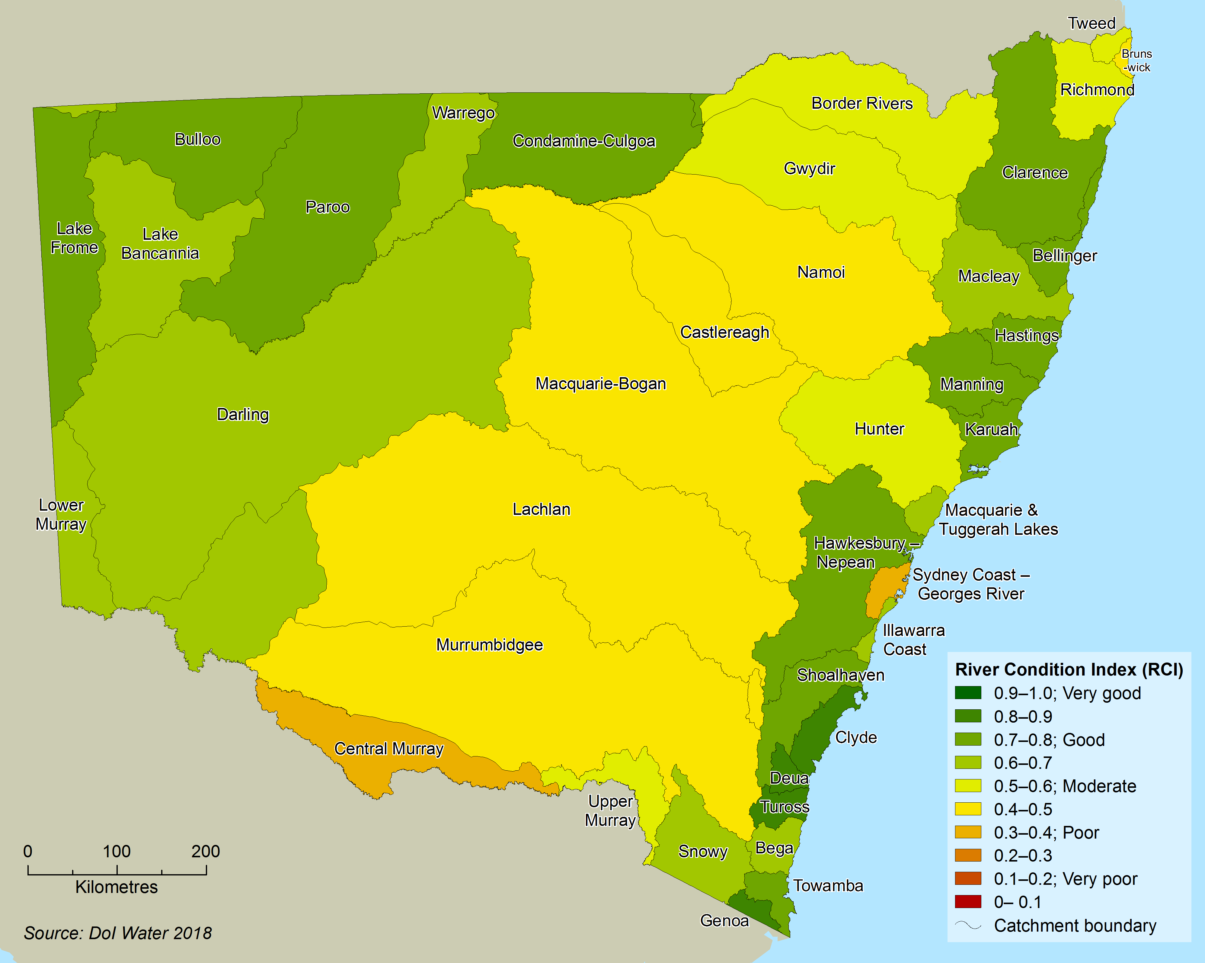
Map 17.1 shows the RCI values for NSW river catchments based on pre-2018 data. Overall, the RCI rated the condition of NSW rivers health as moderate, with 38 out of 40 NSW river valleys having a 'moderate' or better rating. Murray–Darling Basin rivers are generally in poorer condition than Eyre Basin or coastal NSW rivers, while some far south coast rivers are healthiest.
Map 17.1: RCI index value for NSW catchments
Fish
Data on freshwater fish communities for 2018–20 were collected at 566 locations for the NSW Government’s Murray–Darling Basin Plan Environmental Outcomes Monitoring program and the Murray–Darling Basin Authority’s Fish Survey program. While all Murray–Darling Basin catchments were adequately sampled, insufficient freshwater fish assemblage data were collected from most of the coastal catchments.
Other fish assemblage data were collected at an additional 602 locations across the state (including coastal). However, as these were targeted to specific locations, species or ‘events’ (local-scale environmental flow deliveries, fish kills, etc.), they do not provide comparable fish assemblage condition information at catchment scales. Sampling methods and analyses remained consistent with those applied during preceding reporting periods (; ; ).
Health of fish communities in the NSW systems of the Murray–Darling Basin declined during the current reporting period (2018–20), based on scores from a fish condition index (FCI). Three indicator measures make up the score for the overall FCI:
- Expectedness is the proportion of fish species collected at a site compared to the species that would be expected to occur there prior to 1788 (; ). Scores on this indicator declined across all valleys over the last three years, down from an average of 48 to 43.
- Recruitment of native fish is the number of surviving young added to the population. Scores on this indicator declined over the last three years from an average of 42 to 32.
- Nativeness is the proportion of native species to introduced species and comprises the three metrics of species richness, abundance and biomass (; ). Nativeness of fish communities declined across most valleys analysed from an average of 56 to 49.
Based on the above scores, the expectedness and nativeness indicators remained within the poor condition rating band. However, the recruitment indicator declined from a rating of poor to very poor.
Overall, more than 90% (14 out of 15 river valleys) of the fish communities in NSW Murray–Darling Basin river valleys were rated in a poor or worse condition during this reporting period. Table 17.1 provides composite fish condition index values for each of the 15 Murray–Darling Basin river valleys in NSW. In most, the overall condition of freshwater fish communities deteriorated over the last three years.
Table 17.1: Fish condition index for NSW Murray–Darling Basin valleys 2009–11 to 2018–20
| Valley | 2009–11 | 2012–14 | 2015–17 | 2018–20 |
|---|---|---|---|---|
| Border Rivers | Moderate | n/a | Poor | Moderate |
| Condamine-Culgoa | Poor | Extremely poor | Extremely poor | Extremely poor |
| Warrego | Very poor | Very poor | Poor | Extremely poor |
| Paroo | Moderate | Moderate | Good | Very poor |
| Gwydir | Poor | Poor | Poor | Poor |
| Namoi | Very poor | Poor | Poor | Very poor |
| Castlereagh | Very poor | Extremely poor | Extremely poor | Very poor |
| Bogan | Very poor | Poor | Very poor | Poor |
| Macquarie | Very poor | Extremely poor | Extremely poor | Extremely poor |
| Darling | Poor | n/a | Moderate | Very poor |
| Lachlan | Extremely poor | Extremely poor | Very poor | Very poor |
| Murrumbidgee | Extremely poor | Extremely poor | Very poor | Very poor |
| Upper Murray | Extremely poor | n/a | Very poor | Extremely poor |
| Central Murray | Very poor | n/a | Poor | Very poor |
| Lower Murray | Poor | n/a | Moderate | Very poor |
The condition of freshwater fish assemblages deteriorated across seven valleys, with condition declining by one category in three valleys (Upper Murray, Central Murray and Namoi) and by two categories within the Paroo, Warrego, Darling and Lower Murray valleys. It improved by one condition category within three valleys (Border Rivers, Castlereagh and Bogan) and in five valleys remained the same.
None of the NSW Murray–Darling Basin valleys were rated in good condition during the 2018–20 period. Fish assemblages in all other valleys, except for the Gwydir and Bogan (poor) and Border Rivers (moderate) were rated in very poor or extremely poor condition.
To meet Murray–Darling Basin Plan reporting obligations, a new native fish Population Health Index (PHI) was developed in 2020 to provide an objective way of comparing the relative viability and resilience of individual fish species. The PHI provides a consistent means of tracking how native fish populations are responding to long-term conservation interventions, such as the delivery of future environmental flows. The index is calculated for each native species by combining four indicators: abundance, distribution, recruitment and condition.
In the 2014–19 period, only one of 28 native fish, the carp gudgeon, was rated as being in ‘good’ population health in the NSW Murray–Darling Basin. Nine fish species were rated as moderate, representing a stable trajectory of population health. The remaining 16 species (57%) were rated as being in poor or very poor population health. This reflects a substantial decline in one or more of the population health indicators and an overall decline in viability and resilience. The topic has more information.
The biggest threats to the health, abundance and diversity of fish in NSW is river regulation, the destruction of habitat, introduced pest species and the cumulative impacts from a changing climate. Activities and structures that destroy aquatic vegetation, block channels and waterways, and disturb the balance between sediment and water flows in rivers and estuaries are key threats to fish habitats.
Threatened fish species and aquatic endangered ecological communities
Numerous aquatic species are listed as threatened (). Species threatened with extinction are listed as vulnerable, endangered or critically endangered under the NSW Fisheries Management Act 1994.
Eleven freshwater fish species, four populations of freshwater fish, eight freshwater aquatic invertebrates and four ecological communities are listed as threatened under the Act. This includes 36% of all the native freshwater fish species found in the NSW portion of the Murray–Darling Basin. No freshwater species, populations or ecological communities were added to the threatened species lists during the 2018–20 reporting period. No species have recovered sufficiently to be downgraded or removed from the list.
In direct response to severe drought and bushfires impacting many parts of the state in 2018–20, six species of threatened freshwater fish in imminent danger of becoming extinct were collected and held at hatchery facilities as captive source populations. See the topic.
Water quality
Targets
The presence of contaminants and the characteristics of water are used to indicate the quality of water. These water quality indicators can be categorised as:
- biological – bacteria, algae
- physical – temperature, turbidity and clarity, colour, salinity, suspended solids, dissolved solids
- chemical – pH, dissolved oxygen, biological oxygen demand, nutrients (including nitrogen and phosphorus), organic and inorganic compounds (including toxicants)
- aesthetic – odours, taints, colour, floating matter.
The Murray–Darling Basin Plan 2012, Schedule 11, describes targets for water quality that must be met to achieve the basin's environmental, social and economic outcomes. To meet these targets, monitoring identifies trends and informs actions to stem water quality decline.
Water quality at inland monitoring stations in NSW is now assessed against these Basin Plan targets. A review of the plan’s water quality targets in 2020 found them to be largely supported by the jurisdictions (). Most targets are effective and valuable indicators of whether water quality is being maintained at a level appropriate for the beneficial use of the Murray–Darling Basin water resources.
Nutrient data at coastal sites, however, are still assessed using the National Guidelines for Fresh and Marine Water Quality. Regionally-specific water quality targets are being developed for all NSW rivers.
Nutrients
Nutrients such as nitrogen and phosphorus are important for sustaining growth and productivity within rivers, but at high concentrations can lead to harmful algal blooms. Sources of nutrients include runoff from agricultural land, urban stormwater and discharge from sewage treatment works and industry.
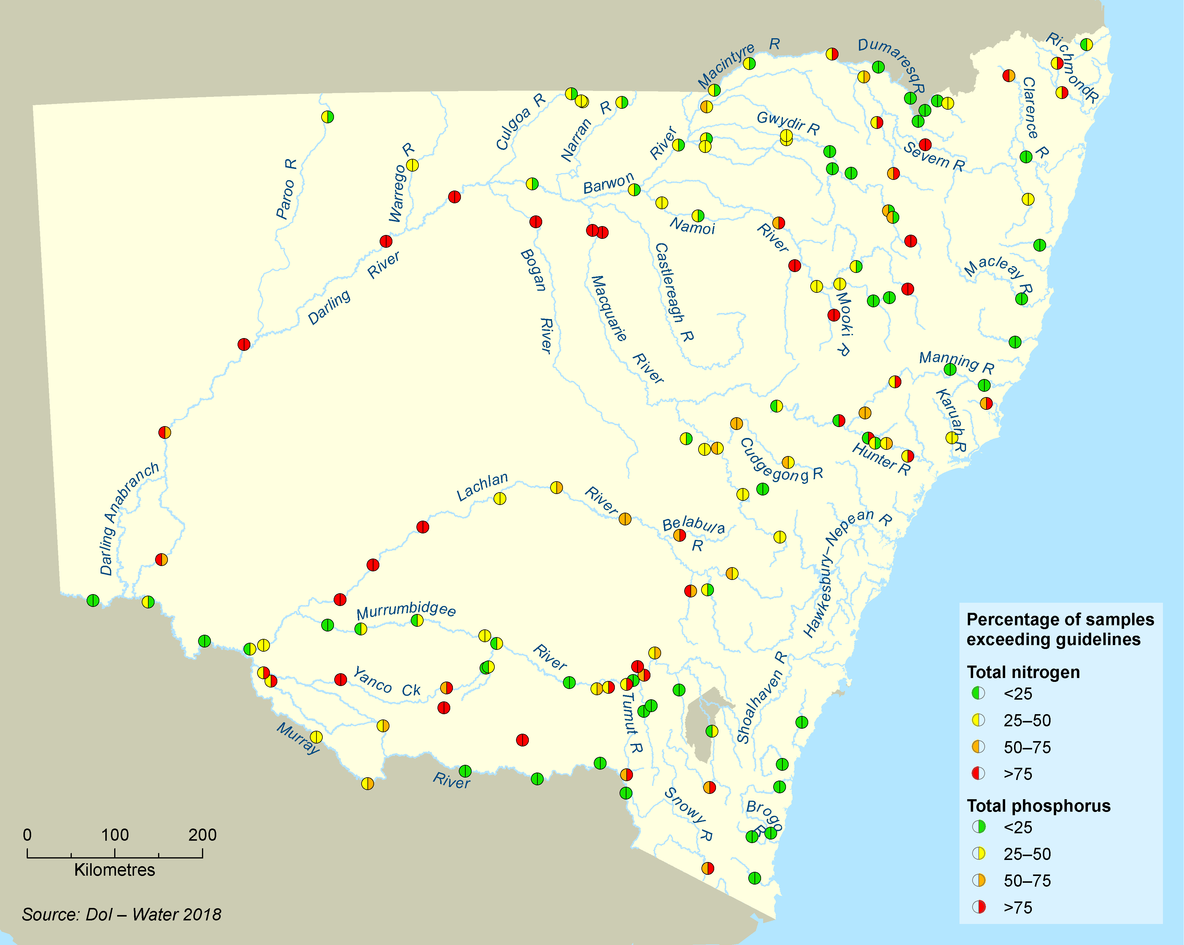
Map 17.2 shows the percentage of water samples from NSW streams with nitrogen and phosphorus concentrations that exceeded water quality targets from 2018 to 2020 (where ‘exceeded’ means they were above accepted targets).
During this reporting period, 37 of the 140 surface water quality monitoring sites sampled across NSW (26%) exceeded the nitrogen and phosphorus targets less than 25% of the time, while 15 sites (11%) exceeded the targets over 75% of the time. Water quality targets were exceeded more frequently at inland sites than coastal sites.
Across NSW, 42% of sites showed no change in exceedance rating compared with the previous reporting period while 34% improved and 24% declined. The extended drought conditions resulted in less runoff washing nutrients into many waterways. At other sites, however, nutrients would have been concentrated in pools through evaporation.
The Macdonald River at Woolbrook in the Namoi montane zone rated poorly with high total nitrogen and total phosphorus levels. This was largely due to the basalt-derived soils in this upland catchment, which are naturally high in nutrients, entering the Macdonald River. High nutrient levels were also recorded at sites on tributaries draining the Liverpool Plains in the Namoi catchment, the lower Lachlan River, lower Macquarie River and Billabong Creek.
Sites in the middle and lower Darling zone also had poor water quality ratings with nutrient levels exceeding targets.
Map 17.2 shows that water quality ratings were generally better at sample sites near the coast, in particular in the far south and upper north coast regions, compared to inland.
Map 17.2: Exceedance of water quality targets for total nitrogen and total phosphorus 2018–20
Elevated nutrient levels occurred in rivers with catchments affected by urbanisation or used for metropolitan urban water supply, such as parts of the Hawkesbury–Nepean and Shoalhaven river systems (not shown on map; see ). These nutrients can originate from runoff from urban and agricultural land and in discharges from sewage treatment plants. Nutrient levels can also be exacerbated by reduced river flows downstream of major dams ().
Discharge of nutrients and other pollutants to coastal waters and estuaries can occur from catchments near the coast. Some will include discharges from industries under the NSW load-based licensing scheme.
More details in the topic.
Salinity
The level of salinity in NSW streams is affected by:
- geology
- climate
- the interaction between surface and groundwater
- land use practices.
High salt concentrations can degrade freshwater aquatic ecosystems. Water used for irrigation water with high salt loads may increase soil salinity, degrade soil structure and adversely affect crop health.
Salinity in water is usually measured as electrical conductivity, the ability of dissolved salts to transmit an electric current. Water with an electrical conductivity less than 1,000 microsiemens per centimetre (µS/cm) is generally considered safe for irrigation. While there are no specific health guideline values for salinity, water is more palatable to humans when the electrical conductivity is less than 940µS/cm ().
Electrical conductivity is monitored continuously at many sites in inland NSW for assessment of long-term salinity trends for the Murray–Darling Basin Salinity Management Strategy (BSM2030) () and end-of-valley targets.
Table 17.2 shows average salinity levels for 2017–20 and the preceding 10-year period (2007–17), at selected mid- and end-of-catchment sites in NSW.
All sites had a mean salinity level below the Australian drinking water palatability threshold for drinking water (940 µS/cm). The Barwon River at Brewarrina, Darling River at Pooncarie and the Hunter at Greta had elevated mean salinity levels but did not exceed the threshold.
Table 17.2 also lists maximum salinity levels at each monitoring point during 2017–20. The palatability threshold for drinking water was exceeded for short periods at some of these locations.
Comparing the data for two time periods (the three- and 10-year averages) shows salinity levels in many streams remained relatively stable, with variations largely dependent on the flow conditions at each site.
Severe drought across most of NSW during the 2017–20 period resulted in low and zero flows in many streams. This concentration of salts by evaporation leads to increased electrical conductivity as was evident in the Darling River at Brewarrina. At other sites, as the smaller saline tributaries in the upper catchments dried up and shallow saline groundwater levels fell, the reduced salt inputs resulted in lower electrical conductivity. In addition, the water level at some sites dried to below the sensor, causing large gaps in data and giving the impression of reduced electrical conductivity.
Table 17.2: Electrical conductivity (µS/cm) in selected NSW rivers 2017–20
| Station number | Station name | Daily river salinity levels (µS/cm) | ||
|---|---|---|---|---|
| Mean July 2007–June 2017 |
Mean July 2017–June 2020 |
Maximum July 2017–June 2020 |
||
| 416012 | Macintyre River at Holdfast Crossing | 291 | 332 | 641 |
| 416001 | Barwon River at Mungindi* | 258 | 308 | 570 |
| 418058 | Mehi River at Bronte* | 453 | 347 | 815 |
| 419001 | Namoi River at Gunnedah | 496 | 490 | 1,059 |
| 419026 | Namoi River at Goangra* | 406 | 430 | 1,036 |
| 420020 | Castlereagh River at Gungalman Bridge* | 546 | 386 | 1,003 |
| 421127 | Macquarie River at Baroona | 440 | 454 | 892 |
| 421012 | Macquarie River at Carinda* | 537 | 560 | 927 |
| 421023 | Bogan River at Gongolgon* | 357 | 482 | 1,010 |
| 412004 | Lachlan River at Forbes* | 467 | 401 | 1,049 |
| 412005 | Lachlan River at Booligal | 537 | 533 | 856 |
| 410001 | Murrumbidgee River at Wagga Wagga | 143 | 115 | 471 |
| 410130 | Murrumbidgee River d/s Balranald Weir* | 170 | 148 | 389 |
| 409005 | Murray River at Barham | 84 | 69 | 133 |
| 414216 | Murray River d/s Mildura Weir | 141 | 115 | 233 |
| 422002 | Barwon River at Brewarrina | 553 | 858 | 3,138 |
| 425008 | Darling River at Wilcannia* | 625 | 523 | 3,110 |
| 425005 | Darling River at Pooncarie | 612 | 670 | 1,110 |
| 210002 | Hunter River at Muswellbrook | 511 | 429 | 880 |
| 210064 | Hunter River at Greta | 799 | 787 | 1,280 |
Notes:
* End-of-valley salinity site
Pressures
Water extraction and altered flow regimes
Natural river flows have been modified by:
- water extraction
- dams and other structures.
Water flows in inland NSW and in coastal river systems supplying major metropolitan areas are particularly affected by dams and other structures (see topic).
Changes to natural river flows, and dampening of their peaks and troughs, affect the critical ecological processes that trigger breeding in birds and fish, enhance recruitment and condition outcomes and provide for movement opportunities within and between systems. These altered flow regimes in rivers are a significant cause of long-term decline in aquatic ecosystems. 'Alteration to the natural flow regimes of rivers and streams and their floodplains and wetlands’ is listed as a key threatening process on Schedule 4 of the Biodiversity Conservation Act 2016.
River flow regimes also play an important role in creating and maintaining the physical habitat of river channels. Not only are they affected by water extraction and physical structures, they are increasingly being influenced by climatic variations and extreme events.
Blockages to fish passage
Many Australian native fish species require access to suitable habitat to complete their life cycles. They need to migrate to spawn, seek food and refuge and to recolonise habitats following drought. The ability of native fish to migrate in NSW has been significantly constrained through the construction of dams and weirs that have contributed to a 90% decline in native fish populations since European settlement. Without specific, targeted intervention to remediate fish passage, native fish populations will continue to decline.
The Fisheries Management Act 1994 lists ‘installation and operation of instream structures and other mechanisms that alter natural flow regimes and streams’ as a key threatening process. These structures:
- disrupt migration of native fish populations
- exclude these fish from large areas of vital breeding and spawning habitat
- restrict their access to food
- limit available shelter for fish, leading to increased predation
- impact water quality and the physical condition of fish
- reduce the genetic variability of fish populations.
A database of fish barriers in NSW, including both in-channel and floodplain barriers, compiled by NSW DPI Fisheries, includes more than 10,000 structures, almost half of which are barriers to fish. Among them are over 2,000 dams, weirs and regulators, the most common type of major barrier. A further 1,800 road crossings and 480 floodgates also impede fish passage.
Infrastructure hazards
Each year irrigators divert a large portion of river water using canals and pumps. This practice of diversion removes significant numbers of native fish from rivers every year. These fish are drawn into pumps and diverted into channels at all life stages, which has a major impact on local and basin-scale native fish populations.
In the Murray–Darling Basin, more than 80% of main channel weirs use an ‘undershot’ (gated) design to control water flows (). Many eggs, larvae and small-bodied fish die when passing through undershot weirs due to the shearing force of turbulent water or collision with concrete or steel infrastructure (; ).
Cold water pollution
When operators discharge water from the bottom of dams, this injects colder water into sensitive downstream ecosystems. This cold water release alters rivers' thermal regimes, sometimes for hundreds of kilometres downstream. Cold water pollution affects a range of physiological and biological processes in native fish species, including feeding, spawning, hatching and larval development (; ).
Eight inland NSW dams have been identified as causing relatively large and pervasive cold water pollution ():
- Blowering
- Burrendong
- Burrinjuck
- Copeton
- Hume
- Keepit
- Pindari
- Wyangala.
Cold water pollution is also a medium pressure downstream from some dams supplying major coastal metropolitan areas, including below upper Nepean catchment dams and the Warragamba Dam.
In some cases, discharges from dams cause downstream temperatures to drop more than 15°C below natural summer conditions ().
Catchment disturbance
Runoff causing water pollution is affected by:
- the extent of vegetation cover in a river catchment
- local land use and land management practices, such as agriculture and urban development.
Runoff may increase nutrients and sediments in the river or stream. It may even modify the geomorphology of the river. Clearing riparian and land plants and draining wetlands also affect river geomorphology by:
- widening river channels
- leading to head cut incisions causing an abrupt vertical drop in headwater streams
- increasing sediment loads, smothering aquatic habitats ().
Generally, the more intensive a development, the greater its impact on river ecosystems.
Healthy riparian vegetation is important to maintain healthy aquatic ecosystems. The structure it provides protects riverbanks from erosion and creates complex habitat and sources of food and nutrients, including for aquatic communities. Intact riverbanks are also critical because many species use overhanging banks and their vegetation for habitat.
River health is affected when riparian vegetation is disturbed. Clearing and trampling by livestock destroys or degrades riparian zone vegetation, with significant impacts.
Other forms of disturbance that influence river health include:
- bushfires
- roads
- large dams
- industrial activities such as mining.
Longwall mining, an underground coal mining technique that can cause the land above to destabilise and collapse, is listed as a key threatening process in Schedule 4 of the Biodiversity Conservation Act. It can lead to cracking beneath a stream or river and the temporary or permanent loss of water flows. This may result in a decrease in water quality due to reduced oxygen availability and enhanced bacterial growth.
Drought
The Australian landscape is adapted to natural drought conditions with many species having life cycles that rely on natural variability in river flows. Prolonged drought, however, causes major disturbance to river systems and can compound the impacts on already stressed aquatic ecosystems.
Where the combined effects of drought conditions and water extraction build up over extended periods, they may exceed critical thresholds in the life cycles of some aquatic species. This stress threatens the resilience and recovery of fish populations. Long-term changes to river conditions have reduced native fish populations, making them less resilient to further changes, such as those imposed by the decade-long Millennium Drought of the 2000s. Large areas of NSW also faced severe water shortages due to drought during 2017 to 2020. As a result, river valleys were managed under the drought stages in the Extreme Events Policy.
Fire
Eastern NSW experienced extensive bushfires throughout the spring and summer of 2019–20, known as the ‘Black Summer’ fires. Approximately 5.4 million hectares of land (7% of NSW) was affected ().
The effects of bushfire on water quality can vary depending on the catchment conditions and rainfall intensity. After a bushfire, ash, burnt material, soil and organic matter is washed into waterways. The impact on water quality can occur straight away and may also persist for years after the fire. Materials washed into rivers and streams can change water chemistry, which can have direct and indirect effects on animals and harm iconic animals, such as fish and platypus, and also affect town water supplies.
Fire affects other components of river condition for years to come through habitat alteration, loss of riparian vegetation, increased streambank erosion, changes to geomorphic condition and loss of biodiversity.
Climate change
Climate change is adding to existing stressors, particularly water availability pressures, catchment and riparian condition and the impacts of altered river flows.
The climate of the Murray–Darling Basin is changing and projections indicate a warmer and drier future. A decline in rainfall will be amplified in the runoff with impacts on agriculture, communities and the environment ().
Most climatic projections suggest an increase in the frequency and severity of drought in NSW, including the possibility of both more frequent prolonged droughts and more frequent short, sharp droughts similar to conditions experienced over 2017–20. At the other extreme, heavy damaging rainfall is also expected to increase. Changes in some types of natural hazards have already been observed in response to the greater frequency and intensity of heat waves and heavy precipitation.
Depending on the region, recent analysis by the NSW Government, as part of the development of regional water strategies, has predicted that climate variability and future climate change could result in changed rainfall patterns, higher evapotranspiration, higher temperatures, more hot days and dry spells, shorter and more severe droughts, a decrease in the number of cool nights, increased intensity of extreme events, rising mean sea level and harsher fire weather.
These changes place additional pressure on the volume, reliability, and quality of water resources in NSW.
Invasive species
Introduced pest fish compete for food and space with native species. They prey on fish and frog eggs, tadpoles and juvenile fish and fundamentally alter food webs and habitats. Freshwater fish surveys by the NSW Department of Primary Industries (DPI) over the past three years have found:
- only 8% of all sites sampled were free from introduced fish, mainly in coastal rivers
- 3% of sites contained only introduced fish
- when averaged across all sites, introduced fish taxa accounted for 38% of fish species collected at each site, 39% of total fish abundance and 61% of total fish biomass
- introduced carp are the most widespread, abundant and detrimental pest in freshwater environments in NSW and were found at 73.1% of sites sampled.
These numbers show little change compared to results reported in NSW State of the Environment 2018.
No new introduced fish species became established in NSW's freshwater aquatic habitats during 2018–20. See also the topic.
Fish kills
Sudden mass mortality events of wild fish are known as ‘fish kills’. Although they can occur at any time, data indicates fish kills are more likely in summer or following sudden changes in temperature. There are a broad range of causes of fish kills, including climatic events (droughts, floods and bushfire), direct human impacts (pollution and fishing) and outbreaks of disease.
Climate-driven processes, such as floods, drought and temperature stress, are the most frequently reported causes of fish kills, with hypoxic blackwater events following large floods and the breakdown of algal blooms responsible for the most fish deaths in NSW. Figure 17.1 shows the sharp increase in the number of fish kill events reported during 2019 and 2020, reflecting the increased instances of drought, bushfire and flooding impacts.
Figure 17.1: Freshwater fish kill events reported 2009-20
The most significant event in the 2018–20 reporting period were a series of three fish kills in the lower Darling River at Menindee between December 2018 and January 2019. These affected a 40-kilometre stretch of river and killed over a million fish, including native fish like Murray cod, silver perch, golden perch and bony herring, and a significant number of introduced carp. From June 2019 to March 2020, further broader-scale fish kills occurred along 600 km of the lower Darling River as disconnected refuge pools contracted and water quality deteriorated ().
An independent expert panel review for the Australian Government concluded that the Menindee fish kill was caused by a combination of low flows, poor water quality and a sudden change in temperature resulting in low oxygen water (). The report also found that a range of factors contributed to the conditions leading to the event, including high fish biomass, high algal biomass, water management practices, water extraction, and climate and drought conditions.
Figure 17.2 shows that these were the most significant fish death events since the widespread hypoxic blackwater events affecting the Murray and lower Darling River from September 2010 to March 2011 ().
Monitoring of the fish assemblage within the lower Darling River following the fish kill events found that Murray cod, golden perch, silver perch and Australian smelt abundance continued to remain low for the 18 months of monitoring following the fish kills. Early signs of recovery were observed for carp gudgeon and freshwater prawn eight months after the fish kills. The abundance of bony herring began to increase 18 months after the fish kills following the resumption of flows in the lower Darling River in March 2020 (). Larval sampling by DPIE during October–December 2020 indicated that several species of native fish had started to breed, including Murray cod, unspecked hardyhead, carp gudgeons, golden perch, bony herring and Australian smelt.
Figure 17.2: Estimated number of fish affected during fish kill events 2009-20
Notes:
The graph employs a log scale, using a factor of 10, to show mega fish kill events in 2011 and 2019–20 that are a couple of orders of magnitude greater than in the normal course of events.
Responses
Legislation and policy
NSW Water Management Framework
The NSW Government’s water policy and management framework includes the 20-year NSW Water Strategy () which addresses the key challenges and opportunities for water management and service delivery across the state and sets the strategic direction for the water sector over the long term.
The strategy is part of a suite of long-term water strategies with 12 regional water strategies and two metropolitan water strategies (Greater Sydney and Hunter region). The strategies link with water sharing plans which remain the legal instruments for managing inland and coastal water resources in NSW under the Water Management Act 2000. These plans are an important component of the water resource plans the NSW Government has developed as part of its obligations under the Murray–Darling Basin Plan 2012. See below and the topic for further information.
NSW Diffuse Source Water Pollution Strategy
Pollution from diffuse sources accounts for most pollution in NSW waterways. The NSW Diffuse Source Water Pollution Strategy () aims to reduce this pollution in all NSW surface and groundwater by focusing on sources not currently regulated. The NSW Government is exploring opportunities to improve the coordination and management of diffuse source water pollution by clarifying roles and responsibilities across government and focusing efforts on the causes of diffuse source water pollution.
Fish habitat policy and guidelines
Policy and guidelines for fish habitat conservation and management aim to maintain and enhance fish habitat in NSW to benefit native fish (including threatened species) in marine, estuarine and freshwater environments ().
Programs
Regional water strategies
The NSW Government is preparing 12 comprehensive regional water strategies that will bring together the latest climate data with a wide range of tools and solutions to plan and manage each region’s water needs over the next 20 to 40 years.
The regional water strategies will integrate and align with other NSW Government programs such as the NSW Water Strategy, long term land use plans for regional NSW, water resource plans, long term watering plans and the Safe and Secure Water Program which provides options to address local-level issues. The strategies are being developed by DPIE over 2020, 2021 and 2022 in partnership with water service providers, local councils, Aboriginal peak bodies, communities and other stakeholders across NSW. Also see the topic.
Water sharing plans
Water sharing plans are important tools to address river health in NSW. They provide for better management of river flows and water extraction practices and protect a proportion of all flows for the environment. Water sharing plans for all NSW water sources have been in place since late 2018 and will be reviewed every 10 years.
These plans provide a clear framework and rules for managing both inland NSW Murray–Darling Basin water resources and coastal water resources. Under the Murray–Darling Basin Plan, water sharing plans underpin 20 water resource plans. Also see the topic.
Water resource plans
The NSW Government has developed water resource plans, which are a key part of the Murray–Darling Basin Plan framework for integrating the basin’s water resource management over the long term. Water resource plans align basin-wide and state-based water resource management and recognise and build on existing water planning processes.
Each water resource plan has:
- the relevant water sharing plan
- a long-term environmental water plan
- a risk assessment
- a water quality management plan
- an incident response guide to deal with periods of drought and poor water quality.
After three years of consultation and discussion with community stakeholders, NSW has 20 water resource plans covering both surface waters and groundwater. The plans are currently being assessed and reviewed by the Murray–Darling Basin Authority. Also see the topic.
Water quality management plans
As required by the Murray–Darling Basin Plan, water quality management plans have been developed for all NSW basin areas with water resource plans.
Each water quality management plan:
- establishes water quality objectives and targets for freshwater-dependent ecosystems, irrigation water and recreational uses
- identifies key causes of water quality degradation
- assesses risks from water quality degradation
- identifies measures that help achieve water quality objectives.
Inland water resource plan risk assessment
Each inland water resource plan includes a risk assessment that examines current and future risks to the condition of an area’s water resources and their continued availability. Strategies are identified to manage medium and high risks in a manner commensurate with the level of risk. Also see the topic.
Floodplain management plans
Floodplain management plans, prepared under the Water Management Act 2000, will help implement the NSW Healthy Floodplains Project. These plans provide a coordinated whole-of-valley framework to assess and determine flood work applications.
DPIE has prepared six floodplain management plans for five valleys in northern NSW:
- Gwydir
- Barwon–Darling
- Upper Namoi
- Lower Namoi
- Border Rivers
- Macquarie valley.
These whole-of-valley statutory plans supersede the 12 localised floodplain management plans previously in force for these six floodplains. They define management zones, rules and assessment criteria that are designed to maintain flood connectivity to important flood-dependent ecological and cultural assets while minimising risks to property.
Coastal risk assessments
In 2020, DPIE commenced development of risk assessments for coastal water sharing plan areas. The documents evaluate risks to water-dependent ecosystems (surface and groundwater) and other uses covered by water sharing plans. Risks to the volume and quality of specific resources and subsequent risks to the users and the environment that rely on them were identified.
Causes, threats and impacts were considered in the risk assessments and a summary of these can be found in Table 16.4 in the topic.
Environmental water holdings
In NSW, water has been purchased or recovered for the environment through a number of water recovery programs funded by the Commonwealth and NSW governments. The cumulative total for all this licensed environmental water for regulated rivers in NSW is 2,478,812 shares or megalitres entitlement (ML), and around 74,362 shares or ML in unregulated rivers. See the topic for further information.
NSW and Australian Government agencies work together to manage environmental water holdings in the context of annual environmental watering plans and strategic catchment or site-based documents, such as long-term water plans and environmental water management plans for specific wetlands.
Environmental flows are also released from dams on coastal river systems that provide urban water supply for major metropolitan areas. The NSW Government has committed to new variable environmental flows from Warragamba Dam by 2024 that will reintroduce more natural downstream flow conditions and improved water quality ().
Fish Passage Strategy
The NSW Fish Passage Strategy has been developed to deliver a coordinated, strategic approach to remediating fish passage. The strategy is a 20-year plan to restore unimpeded fish passage to over 170 priority weirs. This will significantly improve native fish access to nearly 9,000 kilometres of mainstem rivers and key off-channel habitats. Implementation of the strategy’s Phase 1 (2020–25) is underway with remediation activities proposed at over 50 priority sites.
Fish-protection screening
The loss of fish through water diversions can be reduced by over 90% with the use of modern fish protection screens (). However, adoption of these technologies in Australia to date has lagged well-behind the rest of the world.
The NSW Department of Primary Industries is leading the Fish Screens Australia program to bring together scientists, river managers, engineers, water extractors and fishers to promote broader uptake of these screens based on designs suitable for Australian fish and farms.
The use of fish-protection screening is also being promoted in the NSW Water Strategy () and the MDBA’s Native Fish Recovery Strategy.
Climate and data modelling
In 2020, the NSW Government invested in additional climate data and modelling to develop a better understanding of past and future climatic conditions.
When combined with the NSW Government’s NARCLiM climate change projections, the modelling assists with analysis of climate variability and estimating risks to future water availability.
A better understanding of the probability of future climate characteristics, such as the frequency, length and distribution of droughts and floods across regions, can inform mitigation of these risks and the benefits of medium and long-term solutions.
The modelling has been used in the development of the NSW Regional Water Strategies to inform options for water management and improving river health.
Catchment Action NSW
Catchment Action NSW has provided funding to land managers in Local Land Services regions to undertake environmental works. Initiatives under this program have focused on better land management practices in catchments to improve water quality. Examples of projects funded through the program include coastal native revegetation, enhancement and rehabilitation of wetland vegetation and stabilisation of streambanks with engineering works and native vegetation rehabilitation ().
Future opportunities
Continued monitoring will shed light on how habitats and ecosystems respond to the management of water for the environment. This information will refine knowledge and guide adaptive management to better target high-value ecosystems and enhance the benefits of these environmental flows.
The NSW Government has committed, through the NSW Water Strategy, to work with communities to better understand and improve system connectivity which may provide opportunities to improve river health.
Point sources of water pollution are generally well managed. However, scope exists to better manage diffuse source pollution, mainly from agricultural runoff and urban stormwater. Stormwater harvesting developments, runoff controls and initiatives to promote revegetation and better land management practices in catchments can all improve water quality.
There is scope to introduce qualitative information on freshwater species and ecosystems of significance to Aboriginal people, to understand how they are faring and ways to care for freshwater species and their habitats. Qualitative data collection includes oral stories and knowledge about Aboriginal culture and practises. The EPA Aboriginal Knowledge Group has identified a need for management authorities to learn more and apply how Aboriginal cultures and practices improve the care, protection and management of species, their habitats and the overall environment. The Group supports this remerging research and understanding as being essential for understanding and managing all aspects of environmental health.
References
Metropolitan Water 2017, 2017 Metropolitan Water Plan: Water for a Liveable, Growing and Resilient Greater Sydney, NSW Department of Industry, Skills and Regional Development, Sydney
Preece R 2004, Cold water pollution below dams in New South Wales: a desktop assessment, NSW Department of Infrastructure, Planning and Natural Resources, Sydney
WaterNSW 2020, Annual Water Quality Monitoring Report Sydney Catchment Area 2019–20, WaterNSW, Sydney